
Flying safer skies: weather forecasting for air travel
07 December 2021
You’re probably dreaming of the weather at your destination when you head off on a flight. But for airlines it’s the weather while you’re travelling that counts. To get you there safely, minimise delays and run their business efficiently they rely on specialised weather information. So, what weather matters when you're flying and how does the Bureau help keep you safe?
The Bureau works closely with the aviation industry. We forecast conditions that may affect planes while they’re in the air, or as they’re taking off or landing – and even while they're on the ground. Airlines and pilots use weather information to make crucial decisions about flight scheduling and how much fuel to carry. It also help them decide which route to fly and whether it’s safe to fly at all.
What weather can affect flying?
Wind and storms
We've all been there – holding on to our drinks through bumps and shudders when the flight hits turbulence. There are a few contributors to turbulence. These include strong winds running into a mountain range, a significant cold front moving through, and thunderstorms, to name a few. This is one reason why pilots avoid thunderstorms. There can be strong wind within, above and below the storm cloud that can ultimately cause changes to aircraft altitude.
Wind can vary in direction and speed over height, or horizontally. This is called wind shear. Where the variation is quite marked, it can be a hazard to planes. Wind shear is something pilots need to know about when it could cause changes to headwind or tailwind, during flight or on take-off and landing. It can cause added complications when flying conditions are difficult.
Cloud and fog
Clouds can be spectacular to see out the plane window, particularly at sunrise or sunset. However, pilots need to know how much cloud cover exists and how low the cloud starts (called the cloud base).
Pilots of smaller planes operate under 'visual flight rules'. This means that conditions must be generally clear enough for them to see where they're flying. Knowledge of what cloud will be around allows them to plot routes or know if they'll be able to fly at all.
Airline pilots have on-board technology that enables them to fly in cloud. They use instruments and navigate using electronic signals. But safety regulations require them to be able to see the ground by a certain stage of the landing process. So they still need to know about cloud cover and base at their destination.
If low cloud is forecast at the destination airport the pilot will carry extra fuel. This is in case they need to circle as they wait for things to clear. They could even divert to another airport if the cloud stays around. Pilots may also delay departure to take advantage of a better weather window for take-off or landing.
It's the same story with fog, which is essentially ground-level cloud. Fog closes airports and causes flight delays every year.

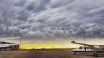
Image: Pilots rely on our forecasts to safely manage take-off, flying and landing around cloud. Mammatus cloud, shown here at Essendon airport in Melbourne, is often associated with thunderstorms, which aviation forecasts also provide information about.
Temperature
Sub-freezing temperatures, along with supercooled (below freezing point) water in the atmosphere, can cause 'icing'. This is when ice builds up on the plane's frame or propellers while it's flying. Icing is a serious hazard. The build-up of ice can alter the weight of the plane and the way its equipment functions. It can even cause engine failure.
It's not just cold temperatures that can cause challenges. It's hot ones too. The reason is that higher temperatures mean a thinner (less dense) atmosphere. This means that the air may not be able to provide enough 'lift' for the aircraft to take off. On a very hot day it may be necessary to make the aircraft lighter. This could mean carrying less cargo or fewer passengers. Or a pilot may need to delay take-off until things cool down.
Space weather
Space weather is different from the weather we're familiar with closer to the ground, but it too can affect flying. It can disrupt the high-frequency radio communications and GPS signals used by pilots and by ground-based systems that help with navigation and landing.
Our information allows pilots to change their methods of communication. They may use higher or lower radio frequencies than those affected.
Volcanic ash
While not weather itself, volcanic ash is carried in the atmosphere and can be very hazardous to planes. Volcanic ash is a mixture of fine pulverised rock, minerals and glass. It's accompanied by gases which convert into droplets of sulphuric acid and other substances. It can melt in the engine, causing loss of thrust (the force that propels the plane through the air) and possible engine failure. It can cause abrasion of engine parts and the body of the plane. It can also clog fuel and cooling systems.
Our Volcanic Ash Advisory Centre is part of a global network of 9 such centres. It forecasts for an area that includes the volcanically active regions of Indonesia, Papua New Guinea and the southern Philippines. It monitors 152 active volcanoes. Our information allows pilots to avoid these dangerous ash clouds and fly only when conditions are safe.
Working with the aviation industry
We provide the meteorological information airlines need to operate safely and efficiently. This means supplying observations, forecasts, warnings and advisories that relate to all the weather and hazards we talk about above – and more.
Some of these products relate to the weather at airports, and others to weather at different levels of the atmosphere. Along with general weather elements such as wind and temperature, we detail the risk of hazards, such as turbulence and icing. Volcanic ash and space weather have their own forecasts and warnings.
We also forecast air pressure. Pilots use this to maintain altitude, according to their pressure-operated altimeter.
We fulfil Australia's obligations under agreements about international aviation. We provide all our services within the technical and regulatory framework of:
- the International Civil Aviation Organization
- the World Meteorological Organization.
Read an overview of our services.
Weather observations from planes and airports
The link between weather and flying is strong. The aviation industry doesn't just use weather services. It also contributes to them. Taking advantage of their position high in the sky, some planes send observations (or readings) of weather elements during flight. The elements they measure include temperature, wind speed and direction, and humidity. It's part of a global system called the Aircraft Meteorological Data Relay.
The observations feed into our weather models, which are a key tool we use to create forecasts. This benefits all weather forecasts, including the ones we all check daily for life on the ground – not just those for flying.
Hundreds of airports, from capital cities to the outback, host weather stations. This means ground-based equipment, capturing a variety of data, also feeds into the weather models.
.jpg)
Image: Checking observations equipment at the weather station at Tullamarine airport, Melbourne
Elements measured include temperature, humidity, air pressure, wind speed and direction, and rainfall. We also measure cloud coverage and visibility, where advanced sensors are installed.
Airport weather stations and observations from planes are part of a huge network of equipment, that gathers data. We also take observations from many other weather stations, weather balloons, weather radars, satellites, ships, undersea buoys – and more. Together, these observations paint a picture of how the weather has been recently, and how it is right now. This lets us model the atmosphere and predict what will happen within the next hour, 3 hours, 6 hours, 12 hours and so on. It allows us to provide critical services to the aviation industry – and allows you to sit back and enjoy the flight.
More information
To check the weather at your destination or your departure point, use the MetEye forecast viewer or the BOM Weather app.

Comment. Tell us what you think of this article.
Share. Tell others.