

Planning for the northern rains
19 August 2022
The annual swing from the dry season (May to September) to the wet season (October to April) in northern Australia broadly marks the return of significant rain to the region. Planning around the timing of the wet season is important for those in the agriculture industry, including graziers, growers and fishers. So if you're in the north, when does the rain usually arrive for your area and what factors can influence this timing?
While October marks the beginning of the wet season, the rains tend to develop gradually – from occasional afternoon showers to more frequent rains as the season progresses.
The northern Australian wet season encompasses the monsoon months but can extend several months on either side. For most locations, the wet season starts long before the start of the northern Australian monsoon, which typically arrives in late December and continues through to around March. The monsoon involves a change in wind direction from south-easterly trade winds to north-westerly winds across Australia's north that draws warm moist air in from the tropics and brings heavy, consistent rainfall to a broad region.
Wet season decisions
For many businesses in the north, timing of the shift from dry to wet can make a big difference to their operations and profitability. Knowing the chance of an early or late onset of the northern rains can assist with key decision-making.
For instance, decisions on pasture stocking rates – animals per square metre of paddock – are influenced by a risk assessment on potential damage to pasture and soil from animals treading on the pasture. Higher stocking rates on wet paddocks can lead to greater damage to pastures and soil.
If a grazier is aware there is a low chance of an early start to the wet season, they can increase stocking rates earlier, meaning more cattle will gain more weight.
For a mango grower, knowing the rains could be early means they can prepare for picking before heavy drops mark the fruit and reduce its quality.
Sugar farmers can also plan their activities with greater awareness of a range of risks that arise with heavy rain: machinery bogging in paddocks, fallen cane that can't be harvested and reduced sucrose content of sugarcane.
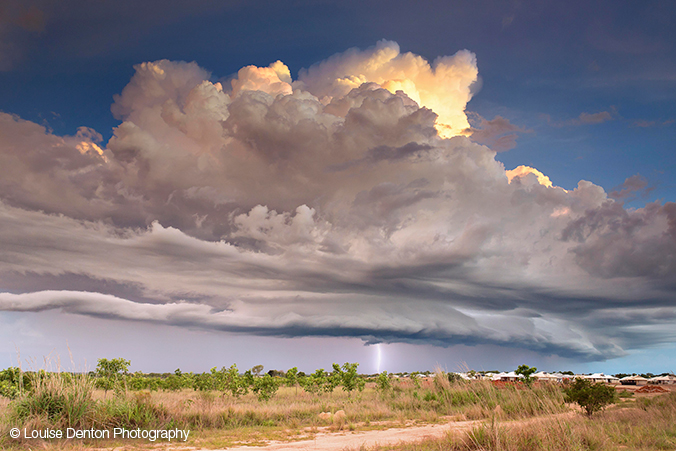
Image: Storm front over Muirhead in the Northern Territory. Credit: Louise Denton
Predicting the start of the wet season
To help agriculture in the north, Bureau researchers, supported by the Managing Climate Variability research and development program, looked at how predictable rainfall was at the start of the northern wet season.
The research focused on the first rains to fall. After consultation with industry, the 'first rains' were defined as the first 50 mm accumulated after 1 September, which is roughly the amount of rain required to stimulate plant growth after the dry season.
The research helped us develop the Northern Rainfall Onset Outlook.This outlook helps businesses and communities in northern Australia understand the chance of an early or late start to the wet season rains.
The Northern Rainfall Onset Outlook gives the likelihood of the first 50 mm of rain after 1 September arriving earlier than its average onset over the period 1981 to 2018. While this probability offers of good indication of likelihood of a certain outcome, it isn't a guarantee. A probability greater than 50% indicates that the odds favour an earlier than average onset.
Research shows that our climate model has good accuracy when it comes to the first northern rains. The physics-based model that we use for our climate outlooks is a world leader in capturing and forecasting tropical events.
Conditions that can drive an early onset of the northern rains are a La Niña in the Pacific, a negative Indian Ocean Dipole, or both. They both lead to an increase in available moisture around northern Australia.
The Northern Rainfall Onset Outlook includes maps that show the average timing of the northern rainfall onset across all years.
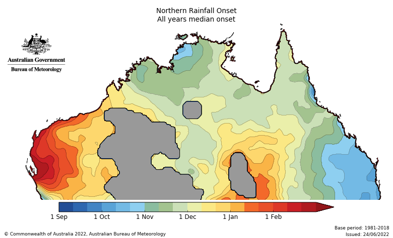
Map showing the average date of the northern rainfall onset, 1981–2018 (grey indicates areas without data from Bureau rain gauges).
For coastal Queensland and the western Top End of the Northern Territory, the northern rainfall onset map indicates that the wet season typically starts in October. In the far west of Western Australia, the onset is usually mid-January.
This information is based on averages. An El Niño or La Niña event can influence a later or earlier start to the wet season. The Northern Rainfall Onset Outlook also has maps of typical onset dates during an El Niño or La Niña event.
Planning for success
By following the odds over the long term, businesses and communities in the north can plan with greater confidence. The Northern Rainfall Outlook is part of a range of Bureau climate information (for example, our Climate Driver Update, Climate Outlooks and climate model summary). Combined with on-farm information, a risk-management overlay and other climate information, the outlook furthers the potential of agriculture in the tropics. It can also come in handy for planning fishing trips.
More information
Subscribe to receive climate information by email.
The wet and the dry: seasons in the tropics
Climate outlooks: stacking the odds in your favour (video)
Long range forecasts: how are climate outlooks made?
Don’t get the butterflies: using a climate outlook is simple
A previous version of this article was published in 2016.

Comment. Tell us what you think of this article.
Share. Tell others.