
How climate drivers affect Australia's snow season
02 June 2023
Predicting snowfall more than a week in advance is tricky, due to its highly variable nature. For this reason, the Bureau doesn't produce long-range forecasts for the snow season. But it is possible to look at Australia's climate drivers to get an idea of what might come along.
Some years have deep snow cover for several months and others have light falls that quickly melt. This natural climate variation is the difference between a bumper ski season, and one where operators rely more heavily on snow-making technology. Climate change also plays a part in observed trends in snow cover in Australia. Warmer temperatures mean precipitation is more likely to fall as rain than snow and can make the snow melt more quickly at the end of the season.
A single weather event can have a big impact on the amount of snowfall and length of the snow season. For example, around a metre of snow fell in less than a week in 2014, approximately the average snow depth during snow seasons between 1954 and 2022.
Peak snow depths are measured at Spencers Creek in the Snowy Mountains in New South Wales by Snowy Hydro. This site provides the longest record of snow depth at high elevations. Its data effectively describes the snow cover across higher alpine regions on the mainland.
Peak snow season in the Australian Alps is usually between June and August. But snow in May is common in alpine areas. There's no link between early snowfall, the amount of snowfall and length of the snow season. In Australia, early snow rarely stays around for long. The only time early snow signalled the start of a sustained seasonal cover was in 1960.
The same climate drivers that affect Australia's weather also influence our snow season and may give an insight into possible snow depths.

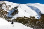
Image: Australia's climate drivers can help indicate what kind of snow season skiers can look forward to.
El Niño–Southern Oscillation (ENSO)
During an El Niño event, rainfall is usually below average across eastern Australia, meaning less snowfall on the Australian Alps. Additionally, during El Niño, temperatures are often warmer during the day.
Each El Niño event is different, and a few El Niño years have had well-above-average snow depths. Since 2000, no El Niño year has produced large snow depths, with these winters tending to be particularly dry.
La Niña usually brings above-average rainfall to eastern Australia but this doesn't always mean more snow. More recent La Niña events have been warmer, meaning precipitation is now more likely to fall as rain than snow. This is most obvious at the beginning and end of the season. Around 60% of La Niña years have had lower maximum snow depths than average.
Other climate drivers
El Niño and La Niña are not the only climate drivers influencing Australia's snowfall.
Positive Indian Ocean Dipole (IOD) years tend to be drier than average across south-eastern Australia. However, unlike El Niño, the effect on snow depths during positive IOD tends to only be in late winter and spring. In contrast, snow depths are generally higher than average during years with a negative IOD.
Cold fronts and low pressure systems are the main weather systems that bring snow. A negative Southern Annular Mode (SAM) brings these weather systems further north towards Australia, increasing the chance of snow-bearing systems during winter across the Alps. During a positive SAM they move further south. away from Australia. This decreases the chance of these systems and therefore snow across the Alps.
The average maximum snow depth in negative SAM years is 200 cm, almost 16 cm higher than in years when SAM is positive. Accurate forecasts for SAM are only possible 2 to 3 weeks ahead.
.png)
Graphs: Comparison of seasonal maximum snow depths for individual ENSO (left), IOD (middle) and SAM (right) events. Years marked in blue: 1954–1989. Years marked in red: 1990–2022. The later time period (marked in red) shows more recent La Niña and negative IOD events usually have lower maximum snow depths. More recent neutral and negative SAM events usually have higher maximum snow depths.
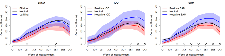
Graphs: Average snow depths measured every 2 weeks throughout the season, with 90% of expected values shaded, for ENSO (left), IOD (middle) and SAM (right) events. The difference between snow depth during the snow season with different phases of ENSO, IOD and SAM is shown.
The role of climate change
Changes in snow cover in Australia are strongly linked to changes in air temperature. Australia's climate has warmed on average by 1.47 ± 0.24 °C over the 1910–2021 period.
Climate change has resulted in a long-term decline in the maximum depth and duration of the snow season since the late 1950s.
Peak snow depths have been decreasing by 0.35 cm/year between 1954 and 2022 at Spencers Creek in the Snowy Mountains, NSW. Exceptions to this trend include the 2017 and 2022 snow seasons, both recording a peak snow depth over 230 cm.
The reduction in snow cover is most obvious at lower elevations and at the end of the ski season when warm spring rains can hasten the melt, shortening the season.
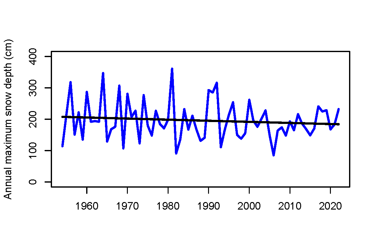
Graph: Annual maximum snow depth at Spencers Creek, NSW, from 1954 to 2022, with a trend line shown in black. This shows the average decrease in peak snow depth over time.
Snow-making in ski resorts
El Niño, positive IOD and positive SAM events all typically mean less moisture in the air, which partly explains reduced snowfall.
But with drier conditions there is less cloud cover to trap heat overnight. This can lead to lower minimum temperatures, which provides good conditions for snow-making and less snow melting.
Ski resorts often make snow and move it where needed to improve snow cover.
Short-term snow forecasting
As snow can be patchy, the online tool MetEye is your best option to visualise where snow is likely to fall over 3-hour intervals in the next 7 days.
The Australian snow season can certainly have large variations in its snow cover, but knowing the state of Australia's climate drivers can give a heads-up on what the season may be like.
More information
The average snow depth and annual maximum snow depth graphics in this article were adapted from Pepler et al (2015).
Subscribe to receive climate information by email
MetEye – your eye on the environment (short video)

Comment. Tell us what you think of this article.
Share. Tell others.