


Bureau warns of significant rainfall for central and southeast Australia
09/01/2015
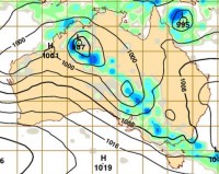
A significant rainfall event is forecast to bring widespread rainfall across central and southern Australia over the weekend with the potential for flooding, including localised flash flooding, in a number of regions.
As the tropical low located over the Kimberley coast begins to track in a southeasterly direction, the Bureau is monitoring the situation closely and will issue specific Warnings for the Northern Territory, South Australia and Victoria.
Western Australia
Heavy falls have already been recorded in Western Australia with Flood Warnings issued in the states northwest. This slow moving system is forecast to track further inland over the weekend, with conditions in Western Australia easing from Sunday.
Northern Territory
In the Northern Territory, daily rainfall totals of over 100mm are forecast for central Australia. The Todd River, in Alice Springs, is flowing for the first time since April 2014. Rainfall is forecast at Uluru with waterfalls over this iconic rock formation since Thursday.
South Australia
Widespread daily rainfall totals in the range of 50-150mm are forecast for South Australia today, and into the weekend, with localised higher falls of up to 200mm possible, which may lead to flash and riverine flooding. South Australia may see its heaviest statewide rainfall totals for a single event since 1974. Fire danger ratings will continue to ease due to lower forecast temperatures and increasing humidity.
Victoria
Warnings for severe weather, heavy rain, thunderstorms and potential flash flooding have already been issued for Victoria. Widespread daily rainfall totals in the range of 50-80mm are forecast across Victoria. Localised falls greater than 100mm are possible over the weekend.
The Bureau urges members of the public to pay close attention to forecast and warnings over the coming days.
Go to www.bom.gov.au for the latest warnings, stayed tuned for emergency media broadcasts and check your local emergency services websites for up to date information in your area.
