Know your weather: kayaking, canoeing and rafting
20 September 2019
Whether you're looking for a relaxing paddle around a calm bay or adrenaline-fuelled white-water rafting, paddle sports are a great way to explore Australia's diverse waterways. However, the weather and water conditions are essential factors in how safe and enjoyable your paddling will be. So how can you make the most of your time on the water?

Plan your paddling trip
Select your dates
Well ahead of time
Weather can vary significantly from day to day, making it difficult to plan your activities well in advance. However, there a few things you can check well ahead of time.
- Streamflows: The flow of water in Australia's rivers and streams is among the most variable in the world. Each month we publish a seasonal streamflow outlook for the next three months, which forecasts the likelihood of high, near-median, and low streamflows at 160 locations.
- Tides: Tides are forecast up to three years in advance, and if you're planning activities along the coastline and in estuaries, they may be important for route access. An outgoing tide may make it more difficult to return to shore, particularly if combined with rip currents.
- Climate: Get to know the typical climate of your paddling location. Australia spans a large range of climate zones with different weather at different times of the year. Consider which months are typically hot, cold, wet, dry, windy, sunny or cloudy.
A few days ahead
Seven days before your chosen date you can access detailed (three-hourly) forecasts for wind, rainfall and temperature. Four days ahead you can access detailed forecasts for waves and swell in marine and significant inland waterway areas. These forecasts can help you pick the best paddling day. The three-hourly forecasts can also tell you when conditions are likely to deteriorate or improve within the day, so you can make informed decisions about when you should go out and come home (read on for more information on this).
We also provide seven-day streamflow forecasts. These give access to forecasts of river volume at 168 locations for the next seven days.
Improve your weather knowledge
It's important you have a good understanding of your abilities and which weather conditions are a risk to your safety. More experienced paddlers may be able to handle rougher conditions while beginners may need to seek out calm conditions. Hazards will also vary by the body of water—from enclosed waters such as inlets and lakes (which offer some protection) to more exposed open waters.
Our top tips for getting weather-ready, well before your activities:
- Familiarise yourself with bom.gov.au. You can also download the BOM Weather app.
- Know where to find weather warnings and understand the type of weather that triggers them.
- Learn how to use MetEye for detailed (three-hourly) weather forecasts, four to seven days ahead. MetEye forecasts are available in 6 km grid cells for all of Australia and its local and coastal waters, meaning you can search for towns, or use latitude and longitude to search for remote locations.
- Identify your closest weather station and/or rain radar to check the latest observations. But also consider whether you will have internet access to view this during your activity.
- Check out the Marine Weather Knowledge Centre if paddling in marine environments. Our blog covers topics that are imiportant for boating and paddlecraft alike, such as cold water shock.

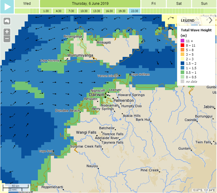
Map: Three-hourly total wave height forecast in MetEye
Beyond the weather
Remember to tell somebody where you're going and bring appropriate clothing, safety and communication equipment. If you are travelling to remote areas or plan to head well offshore, consider carrying a personal locator beacon (PLB) or emergency position indicating radio beacon (EPIRB).
For further paddling tips, see Paddle NSW's Waterways Guide, which covers Australian waterways. The accompanying Waterways Paddle Safe app for iPhones, will enable you to plan your trip, organise your home base, log your start and waypoints, and record emergency details and procedures if you're overdue. Both the website and app display river heights and a paddler-friendly guide to good river levels.
With all paddling group activities, always consider that the paddler with the least ability will determine what, where, and when the group should paddle.
Check the forecast
Check the weather forecast and review it regularly as your paddling trip approaches. Watch for mentions of weather hazards or conditions that could make your time on the water uncomfortable or unsafe, such as heavy rainfall, strong wind, poor visibility, or very high or low temperatures. Consider the weather for your activity but also the journey to your destination and home again.
Inland waterways
- Be aware of river conditions and the potential for flooding in the river or catchment you're in. We publish Flood Watches for early advice and Flood Warnings when flooding is occurring or expected to occur. Flooded creeks or rivers will be dangerous with turbulent flow, debris and submerged hazards. Do not attempt to enter flood water!
- Remember that even if the weather is sunny where you are, what has happened upstream can have a significant impact on water levels (for example, heavy rainfall, thunderstorms, snow melt, or dam releases). Water levels can change quickly after rain, or it might take weeks or even months for floodwaters to reach where you are. Be familiar with your paddling location and the waterways that feed into it.
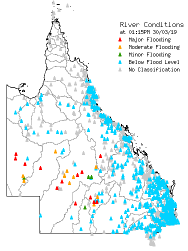
- Real-time river height observations are available at hundreds of locations across Australia. They're a great tool for identifying changing water levels, particularly around flood thresholds. Check out our rainfall and flood map notes for more information.
- Forecast wind wave heights are also available for significant inland waters such as large lakes. Even on inland waters, winds can generate dangerous waves with the risk of swamping your paddlecraft. Forecasts can be found in MetEye (select 'Waves Forecast' then 'Total Wave Height' in the left-hand navigation panel).

Map: Queensland river conditions
Coastal and marine
- Check your Local Waters or Coastal Waters forecast (which are specific to the marine environment). We also recommend checking a detailed map-based forecast in MetEye as conditions can be more complex than a simple text forecast can summarise. For example, winds can vary across different parts of a local or coastal waters area with local effects, like coastline orientation, playing a role in wind speed and direction or timing of wind changes like sea breezes.
- Remember that paddlecraft feel the effects of wave conditions, so even small waves can be quite imposing. If you're a novice paddler, limit yourself to waves less than 0.5 m.
All areas
Pay careful attention to weather and flood warnings, but remember that not all conditions that put you at risk will lead to an official warning. For example:
- even small amounts of rain can result in rapid changes in water levels in some creeks and rivers (but not result in a Flood Watch or Warning);
- all thunderstorms produce lightning and can be dangerous while out on the water (but we only issue warnings for severe thunderstorms); and
- on open water, wind conditions can be difficult or dangerous for small paddlecraft (but Marine Wind Warnings are not issued until average wind speeds are expected to reach 26 knots or 48km/h).
Be aware of ultraviolet (UV) radiation and use sun protection. No matter what the UV index, sun protection is recommended if you will be outside for extended periods. Water is a reflective surface and increases your exposure.
Check the heatwave service to find out when and where heatwave conditions are expected. It uses a heatwave intensity index which is a more advanced indicator of heat stress than minimum and maximum temperatures alone. Heatwave conditions will cause an increased rate of dehydration and heat stroke.
Consider the forecast for 'feels like' (apparent) temperature, which takes into account humidity and wind. This is an important factor for your comfort.
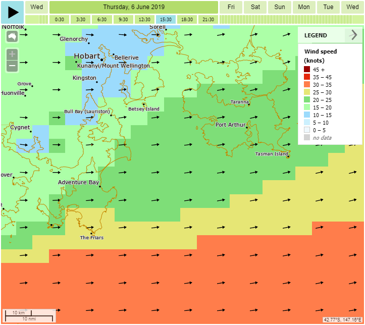
Wind speed and direction can make a huge difference to your enjoyment! Novice paddlers should limit themselves to less than 10 knots and advanced paddlers to no more than 20 knots.
Map: MetEye forecast showing stronger winds offshore (yellow and orange colours) compared to lighter winds (green colours) in protected coastal bays.
Watch the weather while you're out
Stay connected to official information
If you have access, keep checking the Bureau website or BOM Weather app, or listen to the radio to get the latest information. Marine forecasts and warnings are regularly broadcast on marine radio.
Pay special attention if there's a weather or flood warning, and always listen to advice from emergency services.
If rain is expected, keep an eye on the rain radar if one is available in your area.
Watch and listen for signs of approaching weather
Official weather information may not be accessible, particularly if you are in a remote location.
Watch and listen for signs of approaching weather in the natural environment. For example, cumulonimbus clouds or a rumble of thunder may indicate an approaching thunderstorm, rising river levels may indicate heavy rainfall upstream, or increasingly choppy water may indicate wind speed is rising.
Conditions can change quickly, particularly in locations where you can't see the horizon. Leave the water and seek shelter if needed.
More information
- Weather guide for marine outdoor adventure activities
- Weather guide for land-based outdoor adventure activities
- Marine Weather Knowledge Centre


Comment. Tell us what you think of this article.
Share. Tell others.