
Tsunamis in Australia
05 November 2020
Most Australians think of tsunamis as hazards that happen in other countries. Places such as Japan and parts of Southeast Asia have seen devastating impacts. But tsunamis also affect Australia. So what causes tsunamis, when have they occurred in Australia and how do we warn for them?
What is a tsunami?
A tsunami is defined as a series of waves generated by the sudden displacement of a large volume of water.
The sudden displacement can have different causes, such as underwater earthquakes, landslides, volcanic eruptions and asteroid impacts (thankfully these are extremely rare). It can even be caused by jumps in atmospheric pressure. Tsunamis caused this way are called meteo-tsunamis.
Underwater earthquakes are the most common cause. More than 80% of all tsunamis are caused this way. Around 80% of the world's major earthquakes occur on the boundaries of the Pacific Ocean – the so-called Pacific ‘Ring of Fire'.
One important characteristic of a tsunami is that its wavelength – the distance between two successive peaks or troughs – is very long compared to the depth of the ocean. A tsunami wavelength is typically several hundreds of kilometres whereas the ocean is on average 4–5 km deep. This means that the tsunami is defined as a shallow-water wave or a long wave and it can 'feel' the bottom of the ocean.
The result of this is that the speed at which tsunamis travel is determined by the depth of the ocean. They can travel up to 800 km/h in the open ocean but slow down in shallower water. The height of the tsunami and the size of the earthquake are irrelevant when it comes to speed. Understanding this is important when it comes to designing tsunami warning systems.
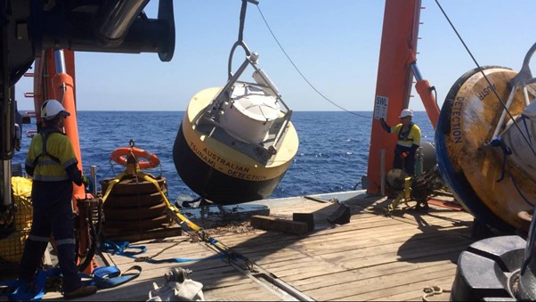
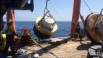
Image: Our tsunami detection buoys measure changes in deep-ocean sea levels and are a critical part of the service provided by the Joint Australian Tsunami Warning Centre.
Which tsunamis have affected Australia?
The Australian tsunami database up until 2014 records 145 tsunamis. This includes 125 events documented since European settlement (about 1 every 2 years). and 20 'paleotsunamis'. These are large tsunamis that occurred before that time. Their occurence can be deduced from sediment deposits or other proxies.
The states with the highest number of recorded tsunamis are New South Wales (57) and Tasmania (40). This is largely because these states are on our Pacific Ocean coastline. They're exposed to tsunamis caused by earthquakes on the Ring of Fire. Next comes Queensland, also on the Ring of Fire, with 26, Western Australia with 23, South Australia with 19, Victoria with 17 and finally the Northern Territory with only 4. If you're wondering why that adds up to more than 145, it's because some tsunamis affected more than one state.
Historical documents suggest that tsunamis may have caused 11 deaths in Australia. These happened in Queensland, Victoria and Tasmania. However, there isn't enough evidence to say that tsunamis definitely caused the deaths. There's a chance that they may have been caused by unexpectedly large wind waves or storm surges.
The largest documented tsunami in Australia occurred on 17 July 2006. A magnitude 7.7 earthquake near Java, Indonesia caused a tsunami that inundated a campsite at Steep Point, WA. Luckily, no one was hurt.
Which areas are most at risk?
Looking at how many tsunamis have affected our coast in the past might tell us something about how frequently they could occur in the future. But it doesn’t tell us how big they might be.
One way of determining which areas of our coast are most at risk is a hazard assessment study. This can be done by carefully considering what we know about:
- where tsunamis are generated
- the size of the earthquakes that generate them
- how they evolve as they travel over the ocean and approach the coastline.
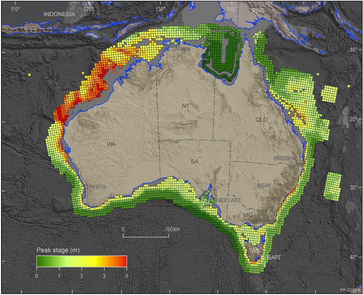
Map: Modelled potential tsunami wave height for a one-in-1000-year event. Credit: © Commonwealth of Australia (Geoscience Australia) 2020
The map above shows the one-in-1000-year wave from a tsunami hazard assessment by Geoscience Australia. You can see that the highest tsunami waves (up to 4 m high) are most likely to occur on the North West shelf, off Western Australia. These would be generated by earthquakes in the north-eastern Indian Ocean.
It's important to understand that a 'one-in-1000-year event' is an event that has a one in 1000 chance of happening in any year. It isn't expected to happen exactly once every 1000 years.
Also the hazard assessment only considers the tsunami behaviour in deep water offshore. Additional high-resolution modelling would be required to understand how these waves would impact land.
Tsunami warnings for Australia
Tsunami warnings for Australia are issued by the Joint Australian Tsunami Warning Centre (JATWC). This is operated jointly by Geoscience Australia and the Bureau. It was established after the Indian Ocean Tsunami of 2004.
The JATWC has three levels of warning. Any tsunami is likely to require different levels of warning for different parts of the coastline. The three levels are:
- No threat: The tsunami does not pose a threat to this part of the coast.
- Marine threat: This warns of potentially dangerous rips, waves and strong ocean currents in the marine environment and the possibility of some localised overflow onto the immediate foreshore.
- Land threat: This is the JATWC's highest level of threat. It warns low-lying coastal areas of major inundation, flooding, dangerous rips, waves and strong ocean currents.
More information
How does Australia's tsunami warning system work?
Reference
Information in this article about historical tsunamis in this article comes from this paper:
Goff and Chague-Goff (2014) The Australian tsunami database; A review, Progress in Physical Geography, Vol 38(2), pp 218–240, accessed 25 October 2020.

Comment. Tell us what you think of this article.
Share. Tell others.