
Know your weather: skiing and snowboarding
05 June 2019
Each year skiers and snowboarders eagerly await the snow season, with fingers crossed for perfect powder and blue skies. So how can you use weather information to make the most of your trip to the snow?
Planning your trip to the snow
Selecting your dates
The official snow season begins on the Queen's Birthday Long Weekend (the second weekend in June) at most resorts. However, the real season begins when enough snow falls and stays on the ground—and this can sometimes be slightly earlier or much later than the official opening date. Resorts may also open earlier if there's enough snow. The Australian season officially ends in early October, although adventures in the back country (areas outside of resorts) often continue for longer as snow up higher lasts well into spring.
The snow season is highly variable. Early-season snowfalls or cold temperatures don't guarantee a good season. However, single weather events can make all the difference, such as the so-called Snowmageddon in 2014, which dropped around a metre of snow in less than a week. Australia's climate drivers also play an important role, tilting the chances towards a better or worse season.
The maximum snow depth is generally reached in August or September. But snow enthusiasts will tell you that the quantity of snow may not guarantee its quality. Colder daytime temperatures (which are statistically more likely earlier in the season) may lead to better snow than warmer spring-time conditions later in the season. However, some snow bunnies will find the warmer temperatures of September more comfortable. The quality of the snow can be affected by dust (which increases the amount of heat snow absorbs from sunlight) or rain (which can soften or wash away the snow).
Ultimately there's no way to exactly predict the weather or snow more than a week in advance of your trip so come prepared for a wide range of conditions.
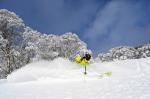
.jpg)
Image: Mount Hotham, Victoria. Credit: Chris Hocking Photography.
Improving your alpine weather knowledge
If you're a snow enthusiast, consider learning more about the weather in Australia's alpine regions, particularly if you're going outside of resort areas.
Alpine weather can change very quickly. Higher altitude and exposed mountain terrain bring a range of potential hazards such as blizzards and white-out conditions (uniform whiteness due to snow, low cloud and/or fog). Prolonged exposure to extremely cold temperatures can lead to hypothermia and frostbite.
Read more on alpine weather safety and watch the video BOM Weather Guide: Snow.
Check the forecast before you go
Checking the weather forecast in the days and hours before you go out skiing and snowboarding is essential. Watch for mentions of weather hazards that could make your time in the snow uncomfortable or unsafe, such as heavy snow or rain or strong wind. You might need to adapt your plans, clothing, and equipment.
Consider the weather for your snow activity but also the drive to your destination and home again. Compacted snow and ice on roads increase risk of accidents while driving visibility can be greatly reduced by snow, fog, or low cloud.
The Australian Alps Weather webpage brings together forecasts and observations for locations within this region. You can also download the BOM Weather app to access weather information on the move.
Our peak tips before you go out:
- While you can access easy-to-read text forecasts for major resort locations, you might want to check a more detailed forecast in MetEye on the Bureau's website,as alpine area conditions can be more complex than a simple text forecast can summarise. MetEye has detailed (three-hourly) weather forecasts, seven days ahead.
- From the MetEye landing page, go to the section for forecasts of Storms, Snow, Rain, Fog and Frost, and select ‘Snow’. Type in your preferred resort or location of interest in the location box at the top of the map—for example, Falls Creek or Thredbo Top Station—and select from the list. You can also type in longitude and latitude to view forecasts for remote back country areas.
- Consider the forecast for 'feels like' (apparent) temperaturewhich takes into account humidity and wind. This is an important factor for your comfort. Wind can make the air temperature feel even colder on exposed skin (wind chill).
- Don't underestimate the risk of ultraviolet (UV) radiation. UV levels are higher at altitude and when reflected off snow. Take sun protection measures for exposed skin and eyes, even during winter.
- Watch for Severe Weather Warnings for widespread blizzard conditions in alpine areas, and other warnings at: bom.gov.au/australia/warnings (or via the BOM Weather app).
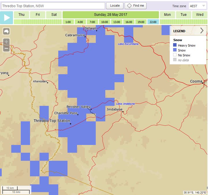
Image: Snow forecast in MetEye.
SunSmart video: why can you get sunburnt at the snow? (begins at 6:07).
Watch the weather while you're out
Stay connected to official information
If you have access, keep checking our website or BOM Weather app, or listen to the radio to get the latest information. Listen to information from emergency services and resort and park managers. Park visitor centres and resort facilities will also have a copy of the weather forecast.
Weather is very changeable and our forecasts are regularly monitored and updated so it's important to check back for the very latest information. If you're on a multi-day skiing or snowboarding trip, the forecast may change while you're there, so be prepared for a range of possible conditions.
Pay special attention to weather warnings. Warnings can be issued days, hours, or shortly before impacts occur. Remember that not all weather conditions that put you at risk will lead to an official weather warning!
Be aware that the rain radar can be limited in mountainous areas and may not show snow.
Watch and listen for signs of approaching weather
Official weather information may not be accessible, particularly if you're in a back country location.
Watch and listen for signs of approaching weather in the natural environment. For example, cumulonimbus clouds or a rumble of thunder may indicate an approaching thunderstorm. Conditions can change quickly, particularly in locations where you can't see the horizon.
Select your terrain appropriately, remembering that avalanches can and do occur in Australia.
Return home or seek shelter if needed.
More information
- Don't be left out in the cold—weather safety in Australia's alpine regions
- BOM Weather Guide: Snow (short video)
- Snow alert: How to make sure you stay on top of the snow this ski season
- Winter weather: what you need to know
- Ten tips for a more detailed weather forecast
- MetEye – your eye on the environment (short video)
- Explainer: avalanches
Also in this series


Comment. Tell us what you think of this article.
Share. Tell others.