
Winter weather: what you need to know
09 June 2018
Australia is famous for its summers but plenty of people also love the cooler months for getting out and about. While the north enjoys warm and dry conditions, southern areas may see snow-covered mountains, foggy airports and winter storms. Whether you love winter or merely endure it, it's important to know what to look out for this winter—and how to keep yourself and your loved ones safe.
Snow
Why take notice: Snow affects limited areas of our mostly flat and dry continent. If you're going to an alpine area, checking the snow forecast will help you avoid unsafe conditions. Depending on the forecast, you may need to adapt your plans or equipment for activities such as skiing, snowboarding, or bushwalking. Heavy snow can reduce the visibility of paths, signs and hazards, making travelling and navigation difficult. Snow, particularly when combined with wind, can increase the risk of hypothermia.
While snow is a cause for celebration among skiers and snowboarders, it can also cause disruption when it falls in large amounts, outside of alpine areas, or out of season. Even small amounts of snow and ice on roads can increase the risk of accidents.
When: Snow is most likely during winter but can fall in alpine regions all year round. Snowfall is dependent on cold-air outbreaks coming from the Southern Ocean and can be influenced by Australia’s climate drivers. This means snow seasons vary a lot; some years we have deep snow cover and others the grass is barely covered. Our snow forecasts help to identify if consistent snow falls are on their way, one week ahead.
How to stay safe: Always check the weather forecast before you go out into alpine regions or other areas where snow is expected.
We have a dedicated Australian Alps Weather web page with weather forecasts and observations for this region. This page includes a Snowy Mountains forecast showing the chance of snow falling at three elevations. If you're on a smartphone use the BOM Weather app.
As snow can be patchy, the online mapping tool MetEye is your best option to visualise where snow is likely to fall over three-hour intervals in the next seven days.
Watch for Severe Weather Warnings that mention 'widespread blizzards in alpine areas'.
Want to know more? Read our blog articles:
- Weather safety in Australia's alpine regions
- Snow: your questions answered
- Snow alert: How to make sure you stay on top of the snow this ski season
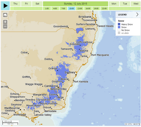
Image: MetEye snow forecast 12 July 2015.
East coast lows
Why take notice: East coast lows (ECLs) are intense low pressure systems with serious impacts. They occur off the east coast of Australia, affecting southeast Queensland, coastal New South Wales, far eastern Victoria, and sometimes Tasmania. ECLs can be slow-moving or even near-stationary, which means the effects usually last much longer than normal low pressure systems or cold fronts. They can generate:
- gale or storm force winds along the coast and adjacent waters, and even the occasional tornado;
- heavy, widespread rainfall leading to flash and/or major river flooding; and
- very rough seas and prolonged heavy swells, causing coastal erosion and inundation.
Falling trees and flash flooding have caused fatalities on land, while many small craft have been lost off the coast and larger vessels have run aground during these events; they're particularly hazardous for boaters.
When: Although ECLs can occur at any time of the year, they are more common during late autumn and winter with a maximum frequency in June.
How to stay safe: Keep watch on the latest weather warnings and listen to advice from emergency services. Over land areas, Severe Weather Warnings are used to warn of the dangerous winds, damaging surf, abnormally high tides that can cause coastal erosion, and heavy rain leading to flash flooding. If needed, Flood Warnings are also issued to warn of river flooding, and Severe Thunderstorm Warnings may also be issued. Over the sea, the standard Marine Wind Warnings are used.
Want to know more? Read our blogs What is an east coast low? and Know your lows: east coast lows (and lookalikes) and watch our Ask BOM video about east coast lows.
Fog
Why take notice: Fog (visibility less than 1000 m) can be a major hazard and inconvenience, particularly to aviation. Fog can stop landings and take offs and close airports, causing major disruptions to flight schedules. If you're out driving or bushwalking, reduced visibility of reference points in foggy conditions can make navigation difficult and increase the risk of accidents.
When: Fog is more likely between May and September than over summer. It may form in the early evening and persist till midday or longer in fog-prone areas.
How to stay safe: Since fog can be patchy, use the online mapping tool MetEye to visualise where fog is likely to occur over three-hour intervals in the next seven days. Drive to the conditions and use your car's lights if there is fog around.
Want to know more? Read our fog explainer.

Image: Monthly fog frequency for selected airports.
Cold air or water temperatures
Why take notice: More than just discomfort, cold air or water temperatures can have extreme effects on your body and its ability to function. Prolonged exposure can result in hypothermia and/or frostbite.
Even in Australia, it can be cold enough, particularly in windy conditions, to cause significant chilling. In wet, windy conditions on land, someone wearing inadequate clothing can become hypothermic even in quite mild temperatures. In the water, a person's survival time will depend not only on the water temperature but also on their physical condition, clothing, access to flotation aids, and other weather and wave conditions.
When: Air and sea surface temperatures change throughout the year due to changes in the amount of sunlight reaching the land and ocean surface. The ocean warms more slowly than the land so there is a lag between changes in the air temperature and water temperature (usually around three months, depending on location). The lowest air temperatures are observed in winter. The lowest sea surface temperatures are usually observed in early spring.
How to stay safe: Good preparation is essential for activities where exposure to cold temperatures may be a risk. Check air and sea surface temperatures—for example by using MetEye—and take the right equipment for the conditions. The Australian and New Zealand Safe Boating Education Group recommends that boaters wear a life jacket and appropriate clothing, learn rescue techniques and first aid, and carry safety equipment.
Want to know more? Read our blog articles about apparent temperature and the dangers of falling into cold water.
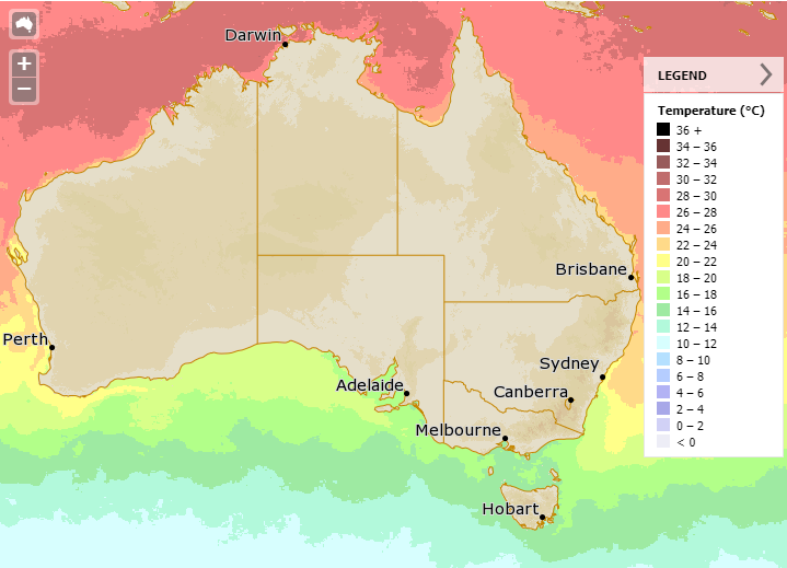
Image: Sea surface temperatures from MetEye, 1 June 2018.
Other hazards
Frost is a common visitor to southern and central Australia from late autumn to early spring. Frost can have a devastating effect on vegetation and costs Australian agriculture millions of dollars each year. Frost can also pose a safety risk on the road, particularly at night and in dips or low-lying areas, where ice may form. Read our blog article Explainer: what is frost?
While ultraviolet (UV) radiation levels are higher in summer, people in many parts of Australia require sun protection measures all year round. Cooler temperatures can also lead people to underestimate UV levels. UV is particularly dangerous when reflected off the snow and at altitude—making sun protection an important preparation for skiers and snowboarders too. Find out the UV forecast (but consider that levels may be higher when reflected).
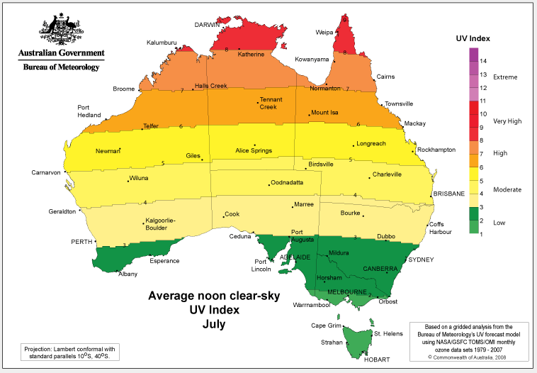
Image: Average UV Index in July.
Bushfires still occur during the winter period. In fact, northern Australia becomes most susceptible to bushfires in the warm, dry and sunny winter and spring, when grasses are dead and fuels have dried. Read our blog articles Australia's bushfire seasons and Understanding fire weather.
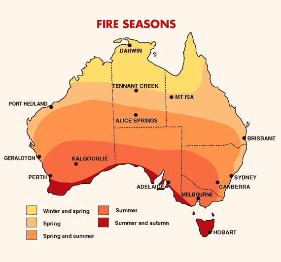
Image: Australia's bushfire seasons.
More information
Keep an eye on the weather outlook for the upcoming months with the seasonal rainfall and temperature outlook.

Comment. Tell us what you think of this article.
Share. Tell others.