

What's the science behind these spectacular weather photos?
25 November 2019
A shimmering aurora australis lighting up the 24-hour darkness in Antarctica. A bird's-eye view of a sublime morning glory cloud rolling out across the sky. Rarely photographed red sprites flickering above a thunderstorm. These and another 10 equally amazing photos are the stars of the show in the 2020 Australian Weather Calendar. So what's going on behind the scenes in the atmosphere to produce the weather in these striking images?
Rare red sprites
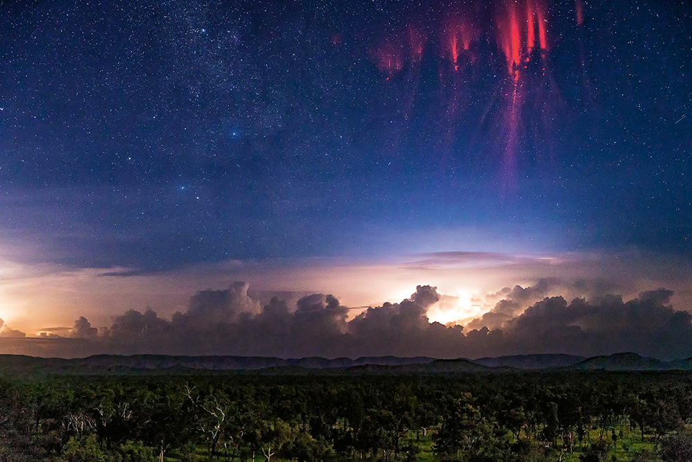
Image: Red sprites above Kununurra, Western Australia. Credit: Ben Broady
Red sprites are a rare phenomenon which is not very well understood. They can occur out of the top of very powerful thunderstorms, and only last for a fraction of a second. Like the process that forms an aurora, sprites are formed by charged particles exiting the top of the storm into the ionosphere. The ionosphere is a layer of the earth's atmosphere, from roughly 50 km above the surface, where solar and cosmic radiation ionise atoms and molecules, thus creating a layer of electrons. This electrically conducting region of the atmosphere is of major importance because it reflects and modifies radio waves used for communication and navigation.
Read more
A bolt from the blue: what is lightning?
Colourful weather: blue jets, elves and sprites
An awesome aurora
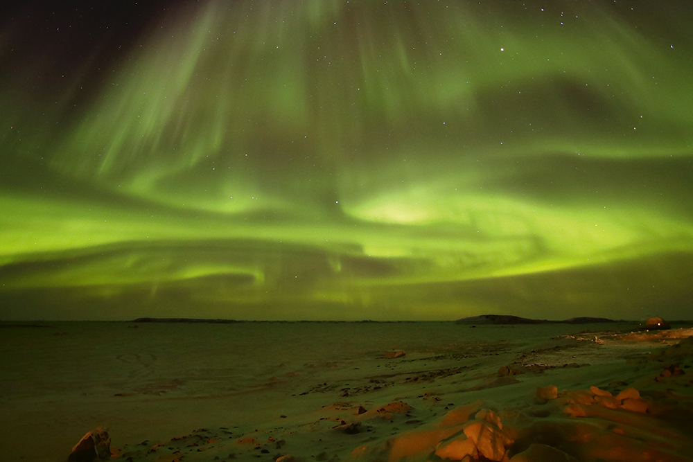
Image: The aurora australis over Prydz Bay, Davis Research Station, Antarctica. Credit: Aaron Stanley, APS Photography
The swathe of green light shown here is a space weather phenomenon called 'aurora australis' or the southern lights—a common sight in Antarctica but sometimes also visible from southern Australia. Auroras are the result of events that begin on the Sun. The Sun is so hot that high-energy plasma (a gas of electrically charged particles) can escape from its gravitational field—known as solar wind. As these charged particles approach Earth, they're directed by the planet's magnetic field towards the north or south poles. Upon entering the atmosphere, they collide with atoms and trigger light emissions. The patterns and shapes of the aurora are determined by the changing flow of charged particles and the varying magnetic fields. The colour emitted depends on how energetic the collisions are, where they occur in the atmosphere and which atoms and molecules are involved. Oxygen releases greenish-yellow or red light, while nitrogen releases dark red or blue light.
Read more
Curious clouds
A magnificent morning glory cloud
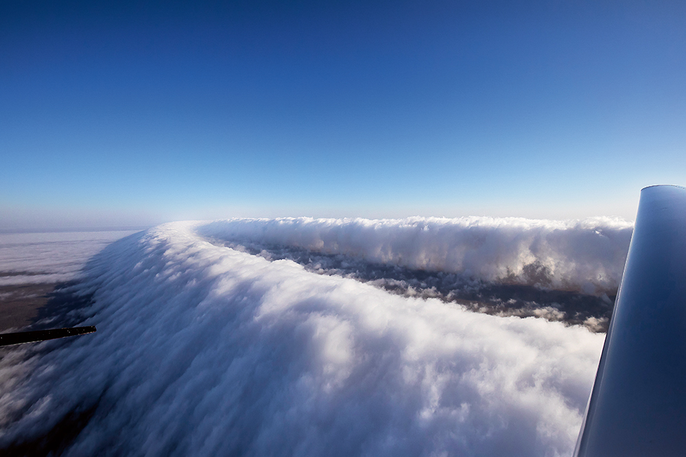
Image: Morning glory cloud, near Burketown, Queensland. Credit: Michael Zupanc
The 'morning glory' is a type of roll cloud which can be many hundreds of kilometres long. They're generally rare, however they occur reasonably consistently across the Gulf of Carpentaria from September to November, with several normally forming during this period.
The cloud is usually formed, in the right conditions, by the interaction between sea breezes on both sides of Cape York Peninsula, which results in a line of cloud. As night falls, the air over land cools and descends while an inversion (a stable layer of air where temperature increases with height) forms over the water in the gulf. The descending air from the peninsula slips under the inversion layer and generates a series of waves which move across the gulf. At the head of each wave, water vapour in the rising air condenses to form cloud, while at the back it evaporates as it descends—forming the roll cloud.
Lava-lamp lenticular clouds
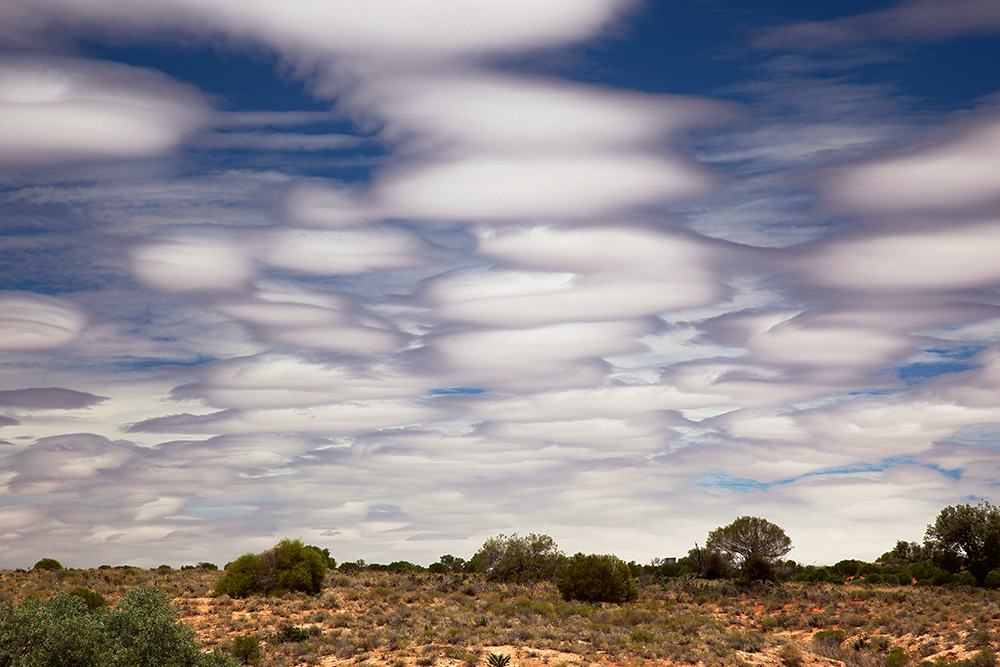
Image: Lenticular clouds near Lake Hart, South Australia. Credit: Cathryn Vasseleu
The cloud shown in this photograph is known as stratocumulus lenticularis duplicatus, commonly known as a lenticular cloud. These clouds are near stationary and lens-shaped, usually forming downwind of a mountain range or elevated area. At times they can also form over ridged ground, as shown in this photo. As wind passes over ridged ground it becomes turbulent due to the disruption to its flow. This sometimes produces a wave pattern in the flow and, under certain conditions, moisture in the air will condense as it moves up towards the crest of the wave, forming cloud. As the moist air descends towards the trough of the wave, the cloud particles may evaporate again, which creates the distinctive lens shape.
A perfect pileus cloud
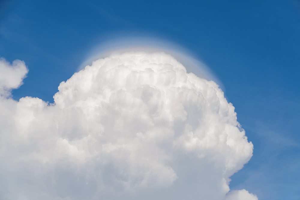
Image: Pileus cloud over Darwin, Northern Territory. Credit: James Dun
The fine, smooth layer of cloud visible above this cumulonimbus (thunderstorm) cloud is a pileus cloud, also known as a cap cloud. Pileus clouds are formed by rising air pushed upwards ahead of the strong updrafts in tall, convective type clouds like this one. Forming high in the atmosphere, they are made of ice crystals. The ice crystals give the cap cloud a very smooth appearance. Occasionally multiple layers of pileus clouds can be visible, before they become part of the bigger cloud.
Moody mammatus clouds
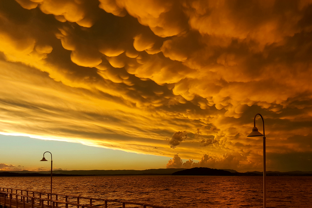
Image: Mammatus clouds, Murrays Beach, Lake Macquarie, New South Wales. Credit: David Macdonald
Mammatus cloud is formed in sinking air. As air descends the water in the air evaporates. Under certain atmospheric conditions this evaporation results in an increased downward movement of air, which drags the cloud down. The result of this is the sagging protrusions from the underside of a cloud known as mammatus. It's most commonly formed in the downdrafts that form in the anvil at the trailing edge of a large cumulonimbus cloud (thunderstorm)—meaning they're often accompanied by showers, lightning, and sometimes hail.
A spectacular shelf cloud
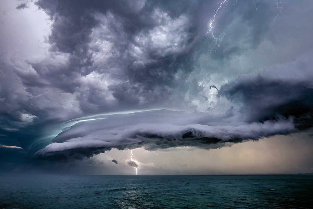
Image: Shelf cloud, Port Macquarie, New South Wales. Credit: Will Eades Photography
A shelf cloud is a low wedge-shaped cloud formation which is usually attached to a cumulonimbus, or thunderstorm, cloud – as shown in this photograph. These clouds are formed by the interaction between a downdraft of cool air coming out of the storm, and an updraft of warm air rising into the storm. As the cool air moves away from the storm, it undercuts the warm air and the shelf cloud is formed at the boundary of the two air masses. The reason for the eerie green glow visible within some thunderstorms, including this one, is still the subject of debate. It seems that the green component of sunlight is scattered preferentially in stronger thunderstorms that contain large amounts of hail and/or larger hailstones—and perhaps also water droplets.
Read more
Clouds: your questions answered
Vivid rainbows
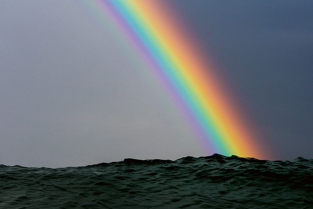
Image: Rainbow over waves at City Beach, Wollongong, New South Wales. Credit: Warren Keelan Photography
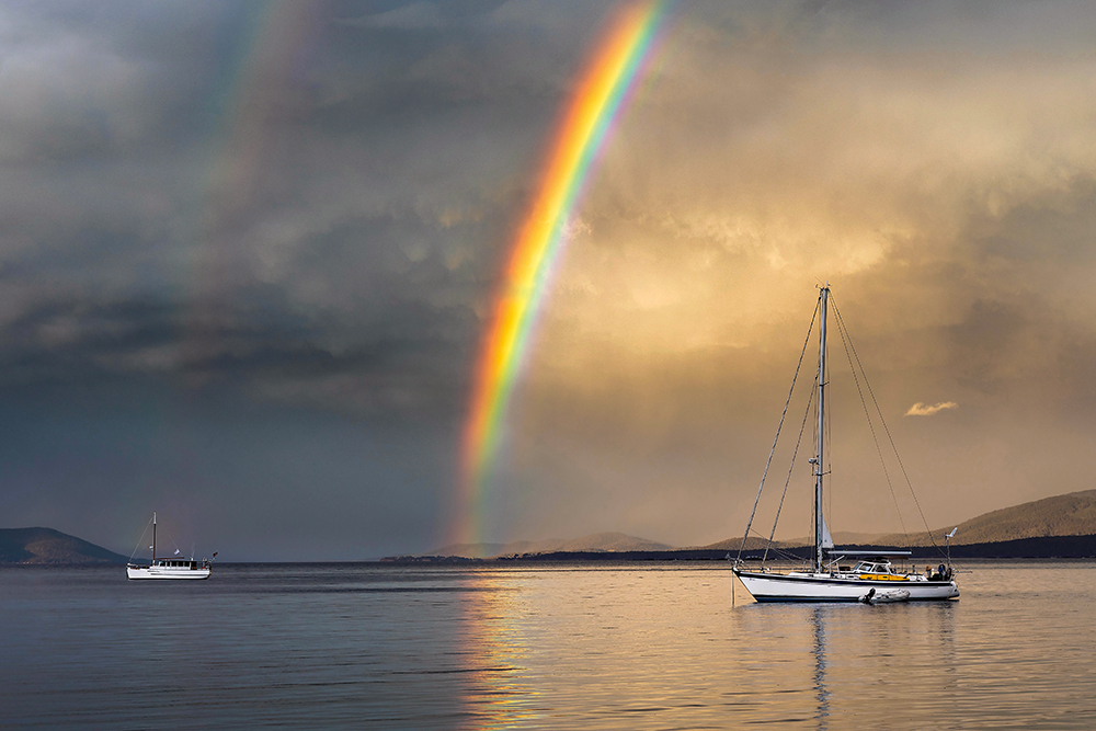
Image: Double rainbow over D'Entrecasteaux Channel (Partridge Island), Tasmania. Credit: Phil Hart
Rainbows are optical phenomena that occur when sunlight and rain combine in a specific way. When white sunlight enters a raindrop, it changes direction (refracts) at the boundary of the raindrop. As different wavelengths within the sunlight refract at slightly different angles, the colours spread out and separate. Some of the light bounces off the back of the raindrop (reflection) and as this light comes back out of the raindrop it refracts again, spreading the colours out further. When you look away from the Sun and towards rain, there is an arc of the sky in which the angle between the Sun, raindrops and the observer is 42°. You'll see just the red light reflected from raindrops in that arc. From raindrops a little lower in the sky, where the angle is 41°, you see just green light reflected; and from drops lower again (40°) you see violet light reflected.
Sometimes a dimmer, secondary rainbow is visible, as shown in Phil Hart's photo above. A secondary rainbow forms when light reflects twice inside the raindrop as opposed to once for the primary bow. The intensity of light is reduced by the second internal reflection, so a secondary bow is always fainter than the primary bow. The order of colours in a secondary bow is always the reverse of a primary bow. This is because the second internal reflection within the raindrop changes the angle at which the light is refracted, and the observer sees the different coloured light in reverse order.
Read more
Cracking lightning
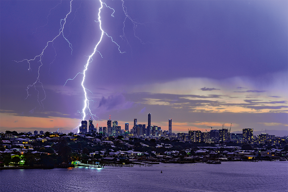
Image: Lightning over Brisbane CBD, Queensland. Credit: Mal Brewitt
Within a developing thunderstorm cloud (cumulonimbus), there are millions of tiny ice crystals and super-cooled water droplets rubbing up against each other as they move up and down. This causes a positive charge to develop at the top of the cloud and a negative charge at the bottom. The negative charge at the bottom of the cloud moves closer to the ground through a faint, negatively charged channel in a series of steps called ‘leaders’, while coming up from the ground are a series of positively charged channels known as ‘streamers’. When one of the negative leaders connects with the positive streamer, a powerful electrical current races from the cloud to the ground—and this is when we see the lightning bolt. Lightning heats the air around it to a temperature of approximately 30 000 °C, which is hotter than the surface of the Sun!
Read more
A bolt from the blue: what is lightning?
A smoky sunrise
Image: Smoky sunrise over Howe Range, Mallacoota, Victoria. Credit: Martin Ascher, Mallacoota Images
The beautiful colours often seen at sunrise and sunset are formed by the interaction of light from the Sun with the Earth’s atmosphere. At sunrise and sunset, the Sun is very low on the horizon and the sunlight has a longer path through the atmosphere. As the light travels through the atmosphere, more of the blue light is scattered, leaving only red, orange and yellow shades in the direct beam. Pollution, dust, smoke and clouds reflect this light, creating a spectacular display of colour—in the case of this photograph, lingering smoke haze from recent bushfires is contributing to the bright orange glow. Alto, or middle-level cloud, such as the cloud shown here, tends to produce the most spectacular sunrises, while cirrus, or high-level cloud, also visible in the photo, can similarly produce a stunning display as the Sun comes up.
Read more
Red sky at night: the science of beautiful sunsets
Ethereal fog
Image: Fog over Lal Lal Creek Valley, Victoria. Credit: Andrew Thomas Photographer
Fog is formed when water vapour condenses into tiny droplets of liquid water suspended in the air. Fog often forms in valleys as air that has been cooled at higher elevations sinks downslope into the valley. The temperature on the valley floor decreases with the arrival of the cold air, and water vapour condenses, forming fog. Generally fog begins to clear after sunrise, as the radiation from the sun heats the air and evaporates the water droplets.
Read more
Delicate frost
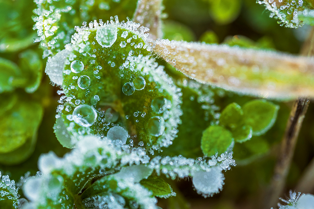
Image: Frost at Jerrabomberra Wetlands, Canberra, Australian Capital Territory. Credit: Lyndal Curtis Photography
Frost is a deposit of soft white ice crystals or frozen dewdrops, formed when the surface temperature falls below freezing point. Frost formation is affected by factors including cloud coverage, humidity, surface winds, topography and location. In Australia, frost is more likely to form under a clear sky, with low humidity and light surface winds. Clouds act as a ‘blanket’ that helps prevent daytime warmth from escaping into space during the night, whereas clear skies mean the heat is free to escape, allowing for lower overnight temperatures. Windy conditions stir up cooler air near the ground, mixing it with the warmer air just above it, slowing cooling at the ground. When it's humid, meaning there's moisture in the air, and water changes from vapour to liquid, small amounts of (latent) heat are released, which also slows the rate of cooling.
Read more
More information
Buy the 2020 Australian Weather Calendar
Australian Weather Calendar photo competition


Comment. Tell us what you think of this article.
Share. Tell others.