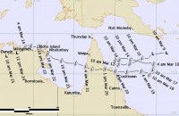
Preliminary information on Tropical Cyclone Nathan now available
28/03/2015

The tropical low that would become tropical cyclone Nathan was first identified and tracked on the morning of Monday 9 March, 2015 in the northern Coral Sea, to the near south of Papua New Guinea.
During the next 36 hours the low drifted towards the west-southwest while slowly intensifying, and was named as category 1 cyclone Nathan on the evening of Tuesday 10 March. The cyclone continued to move west-southwest towards Cape York Peninsula while developing further, reaching category 2 after another 12 hours on the morning of Wednesday 11 March.
Following this, Nathan stalled and became slow moving off the Cape York Peninsula coast near Cape Grenville for roughly two days at category 2 strength. During this time, Lizard Island experienced damaging wind gusts but there was little impact on the mainland.
Go to the Severe Weather Events summary page for more information.


