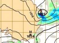
Bureau forecasts further development of East Coast Low
29/04/2015

The Bureau of Meteorology is closely monitoring the development of the East Coast Low off the southeast Queensland coast, and its movement into New South Wales later this week.
Queensland Regional Director Rob Webb said moist easterly winds combined with a strong upper air system are forecast to bring heavy falls to Queensland coastal areas south of Gladstone, extending as far west as Roma.
“The Fraser Coast, Sunshine Coast, Brisbane and Gold Coast are all expected to feel the effects of the low from Wednesday night, with heavy rain, strengthening winds and large swells expected,” Mr Webb said.
Weather conditions over northeast New South Wales are forecast to deteriorate later in the week as the low pressure system moves southwards on Saturday.
Flood Watches have been issued today for several Queensland river catchments and for the New South Wales coastal rivers from the border to Taree.
The public are urged to stay tuned for more detailed forecasts and warnings and follow the advice of local emergency services as this event unfolds.
Falls in the range of 150 to 200mm are expected for southeast Queensland and northern New South Wales between Wednesday and Saturday nights, with localised falls above 350mm possible. The most intense and widespread rainfall will be on Friday and Saturday.
New South Wales Regional Director, Mr Barry Hanstrum, said the main impacts for New South Wales will be in the Northern Rivers and Mid North Coast regions, including Tweed Heads, Lismore, Coffs Harbour and Port Macquarie.”
Mr Hanstrum said the Bureau is acutely aware of ongoing clean-up operations in New South Wales, and mindful of the impact further rain could have in affected areas.
"Further rainfall is possible for catchments that experienced flooding last week, with renewed flooding also possible on Sunday given the saturated landscape. However, we don’t expect to see the extreme rainfall totals and destructive winds that we saw in the last event,” he said.
Coastal gales and locally damaging winds are possible for the Northern Rivers and Mid North Coast as the low moves south, but are unlikely for the Sydney metropolitan and Hunter regions.
Thunderstorms are possible along the coast north of Sydney, which could lead to localised heavy falls.
For further information go to the Bureau's website for the latest Warnings.
The Bureau is now using Twitter to disseminate significant weather information for the community. Follow @BOM_NSW or @BOM_QLD. The Bureau's website www.bom.gov.au remains the most up-to-date and comprehensive official source of information.


