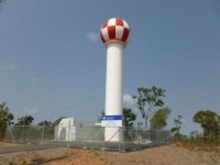
Upgraded Townsville Doppler weather radar now available to the public
20/07/2015

The Bureau of Meteorology has completed an upgrade of the Townsville (Hervey Range) weather watch radar, which will provide Doppler images on its website from today.
The Townsville radar is strategically located in the national radar network, and will provide an enhanced service to allow local communities, emergency services, mining and agricultural stakeholders in Far North Queensland to track local weather.
By adding Doppler, radar images will be more detailed. Doppler functionality from the upgraded radars will provide forecasters with improved ‘nowcasting’ capabilities to more accurately detect and monitor severe weather events such as floods, thunderstorms and tropical cyclones in the densely populated northern regional centres of Townsville and Cairns.
To support the increased data streams associated with this new service, the Bureau has started an upgrade of the communication links. These are expected to be in place by the end of the year.
The Townsville (Hervey Range) weather watch radar was installed in 2011, and replaced the previous radar located at Mount Stuart. The radar is located 21km south west of Townsville on the escarpment of Hervey Range, and sits at a height of 572m above mean sea level.
Radar works through the transmission of electro-magnetic wave pulses that are reflected from particles such as raindrops, hailstones or snowflakes.
Measuring the characteristics of the reflected wave pulses allows meteorologists to obtain information about weather systems within the range of the radar.


