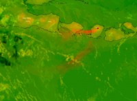
Mt Rinjani eruption ongoing with considerable decrease in strength
18/11/2015

The Bureau of Meteorology continues to monitor volcanic ash from Mt Rinjani, on the Indonesian Island of Lombok, east of Bali, which currently extends to the west of the volcano.
While the eruption from the volcano is ongoing, Indonesia's volcanological agency has advised that it has decreased in strength considerably.
The volcano began erupting 25 October 2015, impacting aviation operations in the region. Winds have carried the ash plume in a generally southwesterly direction, with ash affecting Denpasar airport and disrupting international flights over the past week.
It is not unusual for volcanos to continue to erupt for weeks, and sometimes months, but this will not necessarily have a direct impact on aviation. If you are concerned about your travel arrangements, please check your airline's website for information about any impact on their operations, and be prepared to be flexible as schedules may change.
The Bureau will continue to issue Volcanic Ash Advisories for use by local authorities and the aviation industry operating in the region. Airlines make their own decisions on when to fly based on their risk management approaches.
The Australian mainland is not expected to be impacted by volcanic ash.
Note for media: Satellite imagery (above) showing the volcanic ash plume from Mt Rinjani is available on request, courtesy of the Japan Meteorological Agency.
Background:
The Bureau of Meteorology operates a Volcanic Ash Advisory Centre (VAAC) by international agreement, which provides information to aviation authorities and airlines in Indonesia, Papua New Guinea, Philippines, and Australia during a volcanic ash event in the region.
The VAAC uses ground-based and satellite observations, pilot reports, and sophisticated forecasting models to monitor the current location and forecast movement of volcanic ash.
The Bureau’s advice is provided by agreement with the International Civil Aviation Organization working closely with countries in the VAAC's areas of responsibility. The advice is based on information from volcano observatories and other meteorological agencies in the region, and our specialist satellite tracking and ash dispersion modelling.
Advances in weather prediction models and satellite monitoring are making our observations and predictions more precise. However, much depends on the variability of the ash emissions from the volcano.
The advisories include information on the current location of the volcanic ash, the height in the atmosphere to which the ash extends, and the forecast movement of the ash over the next 18 hours.
Further information on Volcanic Ash Advisories.


