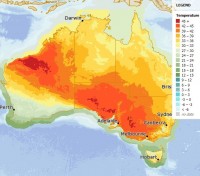
Severe to extreme heatwave conditions to peak tomorrow before relief
18/12/2015

The first significant heatwave for summer has seen severe to extreme heatwave conditions for large parts Australia, and forecast to peak on Saturday.
An extremely hot air mass has seen Adelaide equal its record of three consecutive 40 degree days in December (most recently set in 2007), with this record to fall tomorrow if Adelaide reaches 40 for a fourth consecutive day, as forecast.
Tomorrow large areas of north-western Western Australia, South Australia, Victoria and south-western New South Wales have temperatures forecast in the low to mid-40s, with temperatures over 45 in isolated areas in these states.
Adelaide is forecast to reach 43C tomorrow, Melbourne 41C and Canberra 36C.
Relief from the heatwave will arrive with the passage of a cold front and pre-frontal trough, forecast to move through South Australia late afternoon and overnight on Saturday, pushing through Victoria, Tasmania and southern NSW on Sunday.
The Bureau now provides a Heatwave Service in addition to the temperature forecast, which provides a measure of the intensity of a heatwave, compared to the long term climate average.
Mr John Nairn said the Heatwave Service allows the Bureau to inform the community of the severity of a heatwave, and is able to map the level of intensity of each heatwave event.
“The current event shows large areas of Australia will reach severe heatwave conditions, a more advanced indicator than temperature alone in anticipating the impact of heat stress,” said Mr Nairn.
Severe and extreme heatwaves pose significant risks to human health and safety, particularly the elderly, who are more vulnerable to the effects of heat stress.
When temperatures are unusually hot over a period of time, with continuously high night-time and day-time temperatures, heat stress becomes a critical factor in human survival and infrastructure resilience.
Further information on the Bureau’s Heatwave Service.


