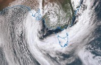
Damaging wind gusts and heavy rainfall
29/09/2016

Joint media release from the Bureau of Meteorology and State Emergency Services - The Bureau of Meteorology in Tasmania is forecasting the low pressure trough currently crossing northern Tasmania to move south across the State during this this evening and tomorrow. This trough will bring heavy rain and strong wind to the north today and to the south of the State overnight and tomorrow.
Regional Director for the Bureau of Meteorology in Tasmania Mr John Bally highlighted the following weather conditions that may pose a risk to the community.
• Strong and gusty northeasterly winds are expected across the north and east today and the southeast of the State overnight. Waves up to 5 metres are expected on the east coast.
A gust of 113 km/h at Tasman Island is the highest recorded today with several stations on the north and east coast recording gusts in the 80-90 km/h range.
• Heavy rainfall is expected with the potential for local flash flooding in parts of the north and east of the state today moving into the south and southeast of the state during Friday.
• Rain totals of 60 to 80 mm in the northeast possibly 120 mm in elevated areas are expected. In the south and southeast rain totals tomorrow are expected to be 20 to 50 mm with up to 90 mm in elevated areas.
• At 2pm today 5 hour rain totals were Fisher River (near Mole Creek) 60 mm. Mt Victoria 42 mm, Meander 31 mm.
• There are expected to be strong river rises in northern rivers with minor to moderate flooding predicted in the Meander, Macquarie, North and South Esk Rivers. On Friday the rain will move to the south and the Bureau is closely monitoring conditions on the Derwent, Jordan and Huon Rivers.
The following weather warnings are current for Tasmania:
Severe Weather Warning for damaging wind gusts and heavy rainfall in Northern and Eastern Tasmania
Coastal Wind Warnings for most coastal waters (gale or strong wind warnings)
Road Weather Alert for Northern and Eastern Tasmania for hazardous driving conditions
Flood Watch for all Northern and Eastern river basins
Flood Warnings for the Meander, Macquarie, North Esk, South Esk and Jordan rivers
Sheep Graziers Warning for the North West Coast, Central North, North East, Midlands, East Coast, Upper Derwent Valley and South East forecast districts
SES Acting Director Brian Edmonds advises the public in affected areas to:
• Drive to the conditions - Do not drive, walk, swim or cycle through flood waters
• People in communities within these catchments should be mindful of the impacts of possible flooding and take precautions
• Beware of damaged trees and power lines, trees & limbs may fall in these conditions
• Farmers and graziers on low lying areas are advised to move stock and agricultural equipment to higher ground
• Secure outdoor items including furniture and play equipment (i.e. trampolines can become a hazard in higher winds)
• Check that family and neighbours are aware of warnings
• Manage pets and livestock
• Be prepared in case of power outages
• Ensure drains and gutters are clear of debris and are running freely
• People in coastal areas should be aware that waves up to 5 metres are possible and to exercise caution
• Disaster preparedness is a shared responsibility
• Stay abreast of road closures by monitoring the Tasmania Police website http://www.police.tas.gov.au/community-alerts or by calling 131 444
• See warnings at www.bom.gov.au/tas/warnings/
• For further detail monitor the Bureau of Meteorology website at www.bom.gov.au
For flood and storm emergency assistance, contact the SES on 132 500. SES has volunteer units on standby.


