Rain on the way for eastern states, south-west WA
17/05/2017

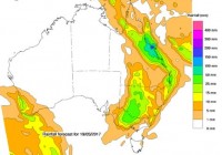
A rain band will move from west to east across Australia's eastern states from Wednesday to Saturday, with the highest rainfall totals expected in Queensland.
Bureau National Operations Centre Senior Meteorologist Scott Williams said smaller rain totals are also expected in areas of New South Wales and Victoria from Thursday, and in Tasmania from Saturday.
In Queensland, a Flood Watch was issued yesterday for coastal catchments from Cairns to Gladstone, including Townsville, Mackay and Rockhampton, extending inland to include parts of the Burdekin and Fitzroy catchments.
"We're looking at Thursday being very active for rainfall on the Queensland coast, especially the area from about Innisfail to Gladstone, with totals broadly 100 to 200 mm in that area," Mr Williams said.
Rain and isolated storms are expected in southeast coastal districts including Brisbane on Friday, with decreasing rainfall in the 25 to 75mm range, and isolated showers and storms could continue on Saturday.
"We'll see a lot of thunderstorm activity develop through western Queensland and extend down into western New South Wales. While the totals won't be as large as in Queensland, isolated locations in western NSW could receive up to 100mm depending on thunderstorm activity. Broadly, we are expecting between 30 and 50mm without thunderstorms over most areas west of the Divide," Mr Williams said.
“Rainfall amounts ranging broadly from 30 to 60mm are also possible along the coast and eastern ranges near the Queensland border. Depending on how this system develops and tracks, and where thunderstorms develop, higher totals are possible locally in that region as well.
"With any significant rain there is the possibility of riverine and flash flooding, however we are expecting rainfall totals and flooding to be generally lower than those following ex-Tropical Cyclone Debbie."
In Victoria, rain will extend across western Victoria tomorrow (Thursday) night into Friday, with falls ranging from 30 to 50mm across the Mallee, Northern Country and Wimmera. Thunderstorms are possible across the north-west late on Thursday, potentially bringing localised heavier falls.
"We expect 10 to 20mm of rainfall across the south-west during the same period and rain will spread to central areas during Friday, with 5 to 15 mm forecast in the Melbourne region before clearing on Saturday," Mr Williams added.
"Northern Tasmania on Saturday looks set to get 30 to 50 mm. There could be some falls there that get to 80 to 100, particularly about the higher ranges."
The Bureau expects to issue a Flood Watch for all northern Tasmanian river basins from Thursday.
Rainfall is also expected in Western Australia, as a series of cold fronts will bring much-needed rain into the south west of the state from Thursday. Rainfall totals of 50mm are possible during the event.
The public should stay tuned for the latest official forecasts and warnings from the Bureau, and follow the advice of local emergency services. Avoid travel, if possible, while warnings are in place and remember: if it’s flooded, forget it.
The most up-to-date official forecasts and warnings are available at www.bom.gov.au and are also available via BOM Weather, the Bureau's official weather app.
The Bureau also shares weather and warnings information via Twitter. Follow @bom_qld, @bom_nsw, @bom_vic, @bom_tas or @bom_wa for information about your state.
NOTES FOR MEDIA:
- A more detailed media release regarding potential for rainfall and flooding for coastal Queensland is available.
- Audio of Scott Williams is available at www.media.bom.gov.au/downloads.


