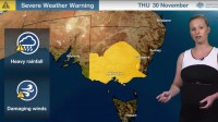
Severe Weather Update: Heavy rain and thunderstorms for eastern Australia
30/11/2017

METEOROLOGIST ANDREA PEACE:
Today marks the start of a significant and widespread rain and thunderstorm event for southern and eastern Australia, with the potential for major riverine flooding to develop through parts of Victoria.
A severe weather warning has been issued for Victoria and southern and central New South Wales, with both states expecting heavy rainfall and New South Wales expecting damaging winds to develop from later today. Severe thunderstorms warnings are also likely to be issued today for most of the southern and eastern states.
And Victoria, New South Wales and Tasmania have also issued Flood Watches––now a flood watch is issued to provide a heads-up for areas that may see river rises or flooding in response to the forecast rainfall. And Flood Warnings are then issued for specific catchments closer to the event as the forecast rainfall becomes imminent or when the rivers start to rise. So as the rain starts falling, it will be important to regularly check warnings for your area.
Now for the last couple of days forecast models have been very consistent in where the heaviest rain will fall.
And this map shows that areas over Victoria for today through to Monday, are likely to experience 100 to 200 mm, particularly northern and central regions of the State. Elsewhere rainfalls are likely to be between 30 and 100 mm in Victoria, but it's the northeast ranges that are likely to see the heaviest falls with up to 300 mm possible about that range area.
Now for New South Wales parts of southern and southeastern NSW, including the ranges in the ACT, falls are likely to be around 100 mm or over, and there may be some localised falls that are even double that. For Tasmania, widespread 50 mm is expected, but again there may some localised falls up to 100 mm.
Now let's break this down day by day.
With the moisture still streaming in from to this high pressure system out in the Tasman Sea bringing in this tropical moisture, so were are likely to see thunderstorms develop over a broad areas of eastern and central parts of the country today. Severe thunderstorms are likely––particularly east of the trough in South Australia and also then extending through western New South Wales and Victoria. Now later this evening the trough will progress east, and we'll see this rain band move into the eastern states.
On Friday, we’ll see a low pressure system develop over northwestern Victoria.
And Saturday is likely to be the wettest day. We’ll see the low drift further south and this trough extend up through New South Wales and into Queensland with a band of heavy showers and thunderstorms.
By Sunday, the low is forecast to move out into the Tasman Sea and into Bass Strait and into the Tasman Sea, we’ll see southerly winds wrapping in around that low, and on the western flank we’re likely to see another burst of rain for central Victoria, including Melbourne. And further north, the trough will move towards northeastern New South Wales and into eastern Queensland. And these areas are likely to experience some significant rainfall on Sunday and Monday.
This will be a significant rain and flooding event for eastern Australia, so please stay up to date with the latest watches and warnings for your area via the Bureau's website and app.
And join us on Twitter for updates directly from the Bureau's meteorologists, and follow advice from emergency services.


