Severe Weather Update Transcript: Hot weather and fire conditions for South Australia and the southeastern states
05/01/2018

METEOROLOGIST ANDREA PEACE: Hello from the Bureau of Meteorology. A short, sharp burst of very hot weather is on the way for South Australia and the southeastern States during Friday and Saturday.
These hot, dry and gusty conditions are likely to lead to elevated fire dangers through parts of South Australia and Victoria on Saturday. The Mount Lofty Ranges and also the Lower South East district are expected to experience ratings of 'Catastrophic'—a level that hasn't been reached in the Mount Lofty Ranges since January 2013.
'Severe' to 'extreme' ratings are also likely to be reached through parts of western and central Victoria, and a total fire ban has been declared for the whole State on Saturday.
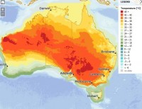
A front will move across western and southern parts of South Australia during Saturday, expecting to reach Adelaide early to mid-afternoon. And ahead of the front, the temperatures are going be very high: Large parts of the country are expected to experience over 40 °C—including Adelaide and Melbourne. And down in eastern Tasmania we're also expecting to see temperatures in the low to mid-30s. Now the winds ahead of the front will be very gusty, particularly close to the change and also about elevated areas.
And immediately behind the change we're going to see a surge of southwesterly winds and they'll bring milder temperatures: Melbourne may experience a 20 °C drop in temperature within two hours of the change moving through during the evening on Saturday.
And while the south will see some relief, the high temperatures still persist through New South Wales during Saturday and Sunday, and we're likely to see large parts of New South Wales move into 'Severe' heatwave over the weekend.
Now the hottest day will be Saturday in the west of the State, but Sunday through eastern parts of the State, with forecast maximums on Sunday including 45 °C at Penrith and 38 °C in Sydney and Canberra. The change is going to be quite weak as it moves through New South Wales during Sunday, so while it will provide some relief to some areas during the evening, because it's going to be fairly weak we'll see those temperatures climb up again during Monday.
So summer is certainly upon us. Please follow all advice from emergency services and state health departments. Stay up to date with the latest forecasts and warnings for your location on the Bureau's website and the BOM Weather App; and you can also get updates directly from the Bureau's forecasters via Twitter.


