SEVERE WEATHER UPDATE: Second update on developing tropical low over the Kimberley in WA
16/02/2018

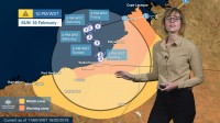
METEOROLOGIST GRACE LEGGE: Hello from the Bureau here with an update on a developing tropical low over the Kimberley. We current have a low over the Dampier Peninsula that is moving west into open waters later today.
As the system continues to moves over water, it is likely to develop into a tropical cyclone. A tropical cyclone warning is in place for communities from Cape Leveque to Pardoo Roadhouse, including Broome. That means that gales force winds with gusts to 100km/hr may develop through those areas in the next 24hrs.
There is a cyclone watch in place for communities from Pardoo Roadhouse to Whim Creek, including Port Hedland, and as far inland as Marble Bar. These areas may experience gale force winds within the next 24 to 48 hours.
As the system continues to move west into open waters it is likely to intensify further into a category 2 system, destructive winds with gusts to 150km/hr could be experienced between Broome and Pardoo Roadhouse early Saturday. As the system turns south late Saturday and into Sunday it may develop into a category 3 severe tropical cyclone and approaches the east Pilbara or far west Kimberley coast.
As this system develops, there is also issues of rainfall through the Kimberley and later Pilbara districts. Around the low we are expected 24hours totals of 50-150mm with isolated falls of 300mm possible. Later through the weekend as the system approaches the coast, rainfall totals will increase through those coastal areas.
Catchments through the north and west Kimberley are already wet due to recent rain and a flood warning is current for both areas due to the expected rainfall causing significant river rises and areas of flooding. A flood watch is also in place for remaining Kimberley and North Pilbara District catchments.
So if you're living in northwest WA, it's time to once again get your cyclone plan ready and listen to the advice of your emergency services.
Check the latest warnings and forecasts on the Bureau website, BoM Weather app and you can follow us on Twitter.


