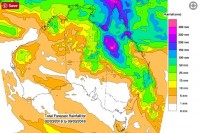
Heavy rainfall, flooding and damaging winds forecast for Queensland's Central and North West
02/03/2018

A low pressure system which has already delivered significant rainfall and flooding around Townsville is tracking to the west today, shifting the focus to Queensland's Central and North West regions, including Longreach and Mount Isa.
Senior Meteorologist Rick Threlfall said heavy rainfall and flooding with locally damaging winds are the main impacts.
24-hour rainfall in the 75mm to 150mm range is forecast, with isolated falls of up to 300mm possible with thunderstorms.
"While rainfall may be welcome in parts of inland Queensland there is still uncertainty regarding the track of the low pressure system and where the heaviest falls will be," he said.
A Flood Watch has been issued for the Central West, Channel Country and Gulf Rivers.
Rivers level rises across remote areas could cause significant disruption to transport and isolation of communities for a long duration. Check for warnings and road closures, and avoid travel if possible when warnings are in place.
Due to recent shower and storm activity across parts of the Gulf, some catchments are already wet and as a result rivers are expected to respond more quickly with flood warnings possible.
If the heaviest rainfall moves further south into the Central West, catchments are a lot drier, but significant rainfall may still result in river levels rising and flood warnings being issued.
Download the BOM mobile app for current weather and warnings and follow us on Twitter @BOM_Qld
The Bureau's website remains the most comprehensive source of weather information.


