Severe Weather Warning for NSW Central Coast
20/03/2018

Stay safe during heavy rain along NSW coast
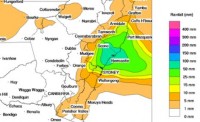
Parts of the New South Wales coast are forecast to see periods of intense rainfall from early tomorrow, prompting a severe weather warning for Newcastle, the Central Coast and Lower Hunter from the Bureau of Meteorology.
In the wake of the hot autumn weather this weekend, meteorologists are now closely watching the development of a coastal trough, which is expected to bring rainfall until the end of the week.
The Bureau's NSW State Manager, Ann Farrell, said wet conditions were forecast for areas east of the Great Dividing Range and the rainfall could become severe in some locations between Taree and Wollongong.
"Weather modelling indicates there will be some very heavy bursts of rain and while the specific areas of greatest impact are still uncertain, we expect to see this occurring from early morning on Wednesday, with more to come tomorrow night," Ms. Farrell said.
"This could be enough to cause road and riverine flooding, and to create dangerous conditions around storm water drains, along with slippery roads.
"Our primary areas of concern for tomorrow are the Central Coast, Newcastle and Port Stephens areas. Sydney, the Blue Mountains and Great Lakes are on the periphery of the worst conditions, but they are regions we will be monitoring closely."
The Bureau has issued a Flood Watch for the Central Coast, Newcastle, Lower Hunter and Manning Rivers.
NSW State Emergency Service Commissioner Mark Smethurst has urged residents of affected areas to get ready early and to act safely once severe weather begins to impact.
“A few simple preparations such as cleaning gutters and downpipes and checking your roof is in good repair can make a big difference in reducing potential damage to your property and reducing calls to our volunteers," Commissioner Smethurst said.
"Once severe weather starts, delay non-essential travel, bring pets indoors, park your car under cover, and most importantly, do not drive in floodwater.
“If you do require emergency help due to storm or flood damage, call the SES on 132 500, or 000 if it is a life-threatening emergency.”
Assistant Commissioner Michael Corboy of the NSW Police Force Traffic & Highway Patrol Command is urging motorists to take extra care.
“Road users should drive, ride, cycle, and walk to the conditions, which in many parts of NSW will involve significant rain and wind," Assistant Commissioner Corboy said.
“The best tip I can offer is for people to slow down. When you slow down it increases your braking distance and time to react to dangers on the road.
“In areas where there is serious rainfall, we urge drivers to pull over where safe to do so and wait for the weather to pass before continuing their journey.
“In heavy weather visibility can be poor, so it is important for cyclists, pedestrians and motorcyclists to wear bright and reflective clothing.
“Do not cross flooded waters under any circumstances, it’s not worth the risk."
Residents are advised to monitor forecasts and warnings closely at www.bom.gov.au
An Audio News Release concerning this event is available for download here.


