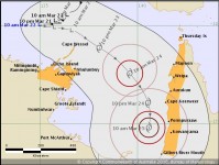
Cyclone Watch in place for a tropical cyclone to develop in the Gulf tomorrow
22/03/2018

A tropical low currently in the Arafura Sea is forecast to reach cyclone strength in the Gulf late on Friday, and further intensify to severe Category 3 strength during the weekend.
Cyclone Watches are in place for both the Northern Territory's northeast and Queensland's Cape York Peninsula coasts.
Queensland State Manager Bruce Gunn said the main impacts will be gale force winds for the watch area and possible coastal inundation of low lying areas. Heavy rainfall and flooding are also risk factors, with many catchments already saturated from recent heavy falls.
"At this stage the low is forecast to track into the Gulf of Carpentaria where environmental conditions are favourable for further intensification during the weekend or early next week.
"Tropical cyclones in the Gulf are notoriously difficult to forecast due to the interaction of sea and land, and we are urging the public stay tuned for the latest official warnings from the Bureau and follow the advice of local emergency services," said Mr Gunn.
Queensland Fire and Emergency Services (QFES) Commissioner Katarina Carroll said residents in the warning area should use the next 24 hours to make preparations around the home.
"Check your roof today and make sure your gutters are clear so that any heavy rainfall can escape easily," she said.
"Make sure you clear your yard of any loose items like furniture that could be picked up and flung around by strong winds.
"Have an emergency kit ready with food, water, clothing, your valuables and regular medication in case you need to relocate.
"Check in with your local council for any information about where pets can be relocated to or any emergency shelter options that will be available if you need to access them."
Ms Carroll said QFES was well prepared and resourced for the possibility of a cyclone impacting the far north of the State and that crews were working closely with local councils and agencies to support preparation activities.
"If you require SES assistance please call 132 500. In a life threatening emergency, always call Triple Zero (000)," she said.
Many catchments are already saturated from recent flooding, and further rainfall may contribute to renewed river level rises and further isolation of communities cut-off by flood waters.
Conditions can change, so it is important to check the Bureau's website for flood watches and updated warnings as required.
Cyclone warnings and further information can be found at: www.bom.gov.au/cyclone
Download the BOM weather app for current forecasts and warnings and follow us on Twitter @BOM_NT and BOM_Qld.
The Bureau's website remains the most comprehensive source of weather information.


