Easter forecast (30 March - 2 April) 2018
29/03/2018

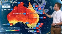
METEOROLOGIST, ADAM MORGAN: Hello and welcome to a special update, as we bring you the forecast for the Easter weekend around Australia.
Most of the country will see fairly settled conditions over the break, but there's still a few important weather features to keep an eye on.
Starting on Good Friday, as many of us begin our travels, we'll see most of the active weather conditions along the Queensland coast. Ex-tropical cyclone Iris in the Coral Sea will continue to move towards the north-west and extend strong winds and showers onto the central and southern coasts. Just a slight chance of a shower along the north tropical coast, though. But after recent torrential rain, river flooding continues. And if you're visiting beaches in southeast Queensland, including the Gold and Sunshine Coast, or along the Byron Coast in New South Wales, please be aware of hazardous surf conditions. Down south, in Tasmania, a cold front during the morning will bring showers; but those showers will contract to the west and far south of the State in the afternoon. Maximums across Australian on Good Friday will be above average through the east and north-east of New South Wales and through Western Australia. On Saturday we'll see the chance of showers along much of the New South Wales coast as a high moves into the Tasman Sea. A fine and sunny day, though, in Victoria and South Australia after early fog patches over southern areas.
Saturday will also see the highest chance across the long weekend of showers and the risk of a thunderstorm around Darwin and the north-west Top End. And showers will increase along the Queensland east coast, with the chance of thunderstorms, as Iris continues to move towards the west, over the Coral Sea, offshore. Maximums near the coast will be close to average on Saturday, but below average for parts of southwest Western Australia and above average through much of inland Australia. And for those of you in daylight savings States, please don't forget to put your clocks back on Saturday night.
Southeastern Australia will wake up on Easter Sunday to a generally settled morning, perfect for hunting Easter eggs. All eyes on Sunday will remain on Queensland, though, where the movement of ex-tropical cyclone Iris becomes more uncertain: It may continue to move slowly west or north-west on Sunday over the Coral Sea, but remain offshore. Temperatures on Sunday will be close to average along the Queensland coast, but well above average for April in the south-east.
And then on Easter Monday there's some chance that Iris will continue to move slowly west and approach the east tropical or central Queensland coast. If this happens, we may see rain areas with thunderstorms and the potential for some heavy falls—particularly on the southern side of the system—but there is still a lot we don't know yet about how the system will move. If it remains offshore, then the heaviest rain would also remain offshore over the Coral Sea. And elsewhere on Monday, as we make our way home from holidays: More showers for Tassie, with an early cold front, and the risk of afternoon showers and thunderstorms across parts of Western Australia. Generally settled, though, across much of the rest of Australia, with a large high pressure system in the Bight. Maximums on Monday remaining above average across much of the country, but close to normal along the south coast and Tasmania, and below average again for eastern Queensland. Have a happy and safe Easter break.
The next update of weather and temperature forecasts will be later on Thursday afternoon, so head to the Bureau's website or app to get the latest information right across the holiday weekend.


