WEATHER UPDATE: Storms and cold snap for eastern Australia
19/11/2018

SENIOR METEOROLOGIST, DR ADAM MORGAN: Hello from the Bureau with the first look at a dramatic shift in the weather across eastern Australia this week.
Warm, humid, springtime weather with showers and thunderstorms will give way to a sharp cold snap later in the week, pushing temperatures back towards winter in the southeast.
First, the thunderstorm risk, which will extend through parts of most States of the eastern half of Australia during the coming days.
It's a very humid airmass that's developing across the east, as it taps into tropical moisture that builds up across northern Australia at this time of year and gets transported towards the south.
These cold fronts in the Southern Ocean will then push ... they'll squeeze that moisture out as they push further east, and that will trigger those showers and thunderstorms.
Later on Monday the first of those fronts will move into South Australia. We can see that sharp temperature change across the front already, pushing into the mid-30s to the east and dropping back to the low 20s further west.
On Tuesday, storms will extend into areas of southern NT, New South Wales, Victoria, and also Bass Strait. And there's a risk that some storms along the trough will be severe, with damaging winds, and with all of that moisture being squeezed we could a see the chance of heavy rainfall as well.
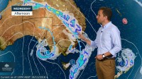
Into Wednesday morning, we may see some heavier rain for parts of northern Tasmania, and then during the afternoon the main storm area will move into northern New South Wales, inland Queensland and central parts of the Territory as well.
While any rainfall will be welcome in regions affected by drought, thunderstorms are always hit-and-miss in nature; so while some places might see a good drop, others will see very little.
Now, see this system here? This is that next cold front that's going to bring that real, bitterly wintry cold weather later in the week. Temperatures in just the high teens for Adelaide on Wednesday and Thursday, and more like 15°C in Melbourne towards the end of the work week.
And this air mass does look cold enough for some snow across the Alps as well.
Beyond Thursday, just how this low develops, with any wind and rain, it's still a little too early to tell. These weather systems are generally quite difficult to forecast this far away, so we'll get a much better idea as we get closer to the time, during the week.
So follow the weather this week on the BOM Weather app, and stay tuned to all the forecasts and warnings as they're updated.


