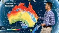
WEATHER UPDATE: 3rd update on thunderstorms & cold snap for eastern Australia
21/11/2018

METEOROLOGIST, JONATHAN HOW: Hello from the Bureau, with an update on the weather systems currently affecting eastern Australia, with storms, strong winds and even snow over the coming days.
Over the past day, thunderstorms stretching from the Kimberley all the way to Tasmania have continued moving east. Some severe storms brought flash flooding and damaging winds, particularly through Central Victoria, including a 104km/hr gust at Viewbank in Melbourne.
Parts of north-west Tasmania saw totals in excess of 50mm, and some sites along the coast registered their wettest November day on record, including for Strahan.
For the rest of Wednesday, the main thunderstorm risk will contract to eastern Victoria, but persist through New South Wales, Queensland and the Northern Territory. Warnings may be issued for these, so keep an eye out if you are in those areas.
Over the coming days, our focus shifts to this low pressure system currently in the Bight which will bring a dramatic shift in weather for south-eastern Australia. The low is set to impact South Australia from today, with damaging winds affecting the southern half of the state including Adelaide, and gusts could reach up to 100km/h along the coast and elevated terrain.
As these strong winds reach further inland, they could kick up areas of raised dust through the Pastoral Districts and western New South Wales.
Dust storms may reach as far as the coast on Thursday, including Sydney and Canberra, and strong winds will also lead to elevated fire dangers for eastern New South Wales.
Further south, and temperatures are set to plummet as that low moves through, and it may even be cold enough for snow down to around 1000m across the Alps.
Into Friday, the position of the low in the eastern Bass Strait will have a large impact on where we will see the worst of the weather. If the low sits a little bit closer to Tasmania, we could see heavy rainfall and very strong winds affect northeastern Tasmania and also Gippsland. On the other hand, if the low sits a little bit further offshore, the impacts will be confined just to coastal areas. By Saturday, that low will move into the Tasman Sea, and conditions will begin to ease.
So with all the upcoming weather on the way, be sure to always follow the advice of your local emergency services, and you can stay up to date with the latest forecasts via the Bureau website, app or Twitter.


