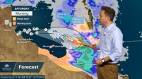
WEATHER UPDATE: Severe tropical cyclone Owen in the Gulf of Carpentaria
14/12/2018

METEOROLOGIST, DR ADAM MORGAN: There's another busy day in Queensland today, with severe thunderstorms in the southeast of the State and severe tropical cyclone Owen, which has finally got his skates on, in the Gulf of Carpentaria—now progressing to the east as a Category 3 system.
Overnight, gales with gusts up to 110 km/h were observed at Centre Island on the NT side of the Gulf.
He's currently located 215 km northwest of Mornington Island, with very destructive wind gusts to 200 km/h near the centre.
A Cyclone Warning continues for the Gulf of Carpentaria coastline stretching from the NT/Queensland border to Aurukun, including Mornington Island.
A Cyclone Watch extends inland across Cape York Peninsula through as far as Coen, Chilagoe and Georgetown.
We expect Owen to reach Category 4 intensity today as he continues to move towards the east.
Owen is expected to cross the southeast Gulf of Carpentaria coast late tonight or early Saturday, potentially as a Category 4 severe tropical cyclone.
On top of those very destructive wind gusts near the centre, storm surge will be a risk.
With landfall potentially on an outgoing tide, we may see storm tide heights approaching the usual highest tide of the year.
Very heavy rain is also likely, and Flood Watches are current for the Gulf of Carpentaria and southern Cape York Peninsula.
Further into the weekend we still expect Owen to weaken to below cyclone intensity and track inland towards the southeast, towards the east coast of Queensland.
Even with Owen as a tropical low, it will remain a potentially high impact event; with heavy rain, locally damaging to destructive winds, severe thunderstorms and abnormally high tides.
We have a Flood Watch in place for numerous catchments down along the east coast of Queensland, with widespread flooding likely over the weekend and into next week.
With Owen tracking fairly briskly, flash flooding in particular will be a risk, especially in parts of north Queensland that received rainfall from Owen the first time around.
Towards the end of the long-term forecast period, the exact extent of how far down along the east coast Owen may move remains a little less certain, but we're looking at scenarios that include the stretch of coast from Townsville down as far as Wide Bay.
The range of track scenarios still in play is shown by the grey, shaded area on the map around that official forecast track.
Cyclones remain a challenge for the best computer weather models from Australia and around the world to predict; and, as we all know, cyclones can move erratically and each has a unique personality.
The track shown here is the current official forecast track, hot off the press and based on the very best information we have available right now.
So as the situation continues to evolve, make sure to stay tuned to the Bureau website for the latest cyclone warnings and forecasts; and please follow all advice from emergency services.


