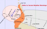
WEATHER UPDATE - Tropical Cyclone Penny has formed over far north Queensland
01/01/2019

METEOROLOGIST JONATHAN HOW: Hello from the Bureau, with an update on the tropical cyclone that has formed over far north Queensland.
Over the past twenty-four hours, a tropical low in the Gulf of Carpentaria has continued to intensify, and on Tuesday morning was named Tropical Cyclone Penny. Penny is currently a Category 1 system and is moving towards Queensland's western Peninsula coast.
A tropical cyclone warning has been issued for coastal and adjacent inland areas from Pormpuraaw up to Cape York, for gales of up to 120 km/h, and there is the also the risk of heavy rainfall and higher than normal tides along the coast. Penny is expected to make landfall near Weipa during Tuesday afternoon or evening, most likely as Category 1 system, however, if the cyclone does stall for slightly longer over the water, there is a chance that it could reach Category 2 before crossing the coast.
The cyclone will weaken and fall back to tropical low as it moves over land, and our latest forecast has the system reaching the Coral Sea on Wednesday morning.
Outside the immediate cyclone threat area, there are still severe weather warnings in place, for heavy rainfall around the Cape Melville and Lockhart River area, and damaging winds and abnormally high tides further north, including the Torres Strait Islands. The rain has eased around the Daintree and Cairns area, and the Daintree River has dropped below Moderate flooding levels, but there is still a flood watch for catchments across the Cape York Peninsula.
Once Tropical Cyclone Penny weakens and moves over the Coral Sea, conditions again become favourable and the system could be re-classified as a Tropical Cyclone as early as Thursday, but it will be far enough offshore that it won't affect the east coast.
Beyond Thursday, there is still significant uncertainty as to how the system will move and develop. Consensus has grown among the computer models that the tropical cyclone could start re-curving back towards the land by the weekend, however it's still too early to forecast what kind of impact this may have on the east coast.
Tropical cyclone situations can change quickly, and here at the Bureau we're keeping an eye on the situation 24/7. So remember to stay up to date with the latest warnings and forecasts via the bureau website or app, and for those in far north Queensland, always follow the advice of your local emergency services.


