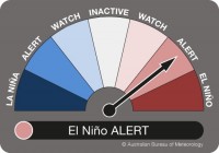
Chance of El Nino increases as tropical Pacific Ocean temperatures warm
19/03/2019

The Bureau of Meteorology has raised its ENSO status to El Niño ALERT, meaning the chance of an El Niño forming this year is now around 70 per cent, or roughly three times the normal likelihood.
Prior to today's update, the Bureau's ENSO status had been at El Niño WATCH since January.
The Bureau's manager of long-range forecasting Dr Andrew Watkins said changes had been observed in the Pacific Ocean meaning the likelihood of an El Niño event has risen over the past month.
"In recent weeks, we've seen a warming in sea surface temperatures in the tropical Pacific Ocean to near El Niño thresholds, and a number of international models, including our own, are suggesting the warming will continue as we move closer to winter," Dr Watkins said.
"These changes in the ocean are often a precursor to an El Niño. We're now also seeing some signs of the atmosphere responding to this warming of the Pacific Ocean temperatures, and if this persists, weather patterns around the globe may also change."
Dr Watkins said El Niño events typically mean a drier than average winter and spring for eastern Australia, and warmer than average conditions in the south.
"It's important to remember that the strength of an El Niño doesn't always reflect the severity of the impacts.
"For example, we've had very strong El Niño events that have brought mild impacts, but we've also had the flipside with weak El Niño's bringing much more severe impacts.
"We'll be monitoring conditions in the Pacific Ocean very closely and will provide the Australian community with the very latest information should we see further developments."
The very latest ENSO Outlook and information on the impacts of an El Niño can be found at: http://www.bom.gov.au/climate/enso/
The Bureau's seasonal forecasts for rainfall and temperature can be viewed at: http://www.bom.gov.au/climate/outlooks/


