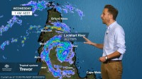
WEATHER UPDATE: tropical cyclone Trevor to move into the Gulf of Carpentaria, 20 March 2019
20/03/2019

Senior Meteorologist, Dr Adam Morgan: Hello again. Tropical cyclone Trevor continues to track west across Cape York Peninsula.
Currently it's a category 1 system, having weakened a little this morning. The Cyclone Warning zone covers the stretch of coast along Western Cape York between Pormpuraaw and Cape York. Heavy rain and gales gusting to over 90 km/h are impacting western parts today and we'll see abnormally high tides this afternoon and tomorrow morning along the coast to the north of the cyclone's centre.
The Cyclone Watch zone extends further south, to Kowanyama, and a Severe Weather Warning for heavy rain is in place for eastern parts of the Peninsula as the monsoon trough lingers. A little further south we have Flood Warnings for the Daintree and Mossman rivers and a Flood Watch remains in place for catchments north of Innisfail to Kowanyama. We've also just issued our first Cyclone Watches for the entire NT Gulf Coast around to Nhulunbuy, ahead of the likely arrival of cyclone Trevor towards the weekend.
Trevor made landfall along the east coast of Cape York late Tuesday afternoon. Lockhart River saw wind gusts to 137 km/h and recorded 302 mm of rain in the 24 hours to 9 am this morning. Trevor is currently tracking close to Aurukun and will push off into the Gulf of Carpentaria this evening.
We'll see Trevor re-intensify quickly in the Gulf and it's likely to become quite a large cyclone. There's still a range of possible outcomes for how Trevor may move, which is why we've placed such a large stretch of coast along the NT under Cyclone Watch, and we'll narrow that down over the coming days; but right now the most probable path—the official forecast track—shows Trevor moving towards the Southwest Gulf Coast, potentially reaching severe category 4 intensity well before landfall. Gales may develop on Groote Eylandt as early as Friday morning.
Cyclone Trevor is impacting Cape York Peninsula now and residents in the path should take shelter and remain in safety.
NT communities along the Gulf Coast should begin their preparations now and finalise their emergency kits. Follow all advice for emergency services and stay in touch with the Bureau for latest forecasts and warnings.


