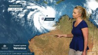
WEATHER UPDATE: Tropical cyclone Veronica northwest of Western Australia
20/03/2019

Senior Meteorologist, Andrea Peace: Hello from the Bureau with an update on tropical cyclone Veronica, which formed to the north of the Kimberley in the early hours of today (Wednesday morning).
The tropical low intensified a rapidly yesterday and we expected it to continue to intensify in the coming days to a severe category with a severe tropical cyclone and coastal crossing possible for the Pilbara coast over the weekend.
And while no impacts are expected along the WA mainland for the next 48 h, communities along the Pilbara coast should begin preparing now for what could be a dangerous period over the weekend with the passage of this slow-moving and intense system—likely to lead to significant impacts from prolonged wind, storm surge and flooding. And the current track map shows that Veronica is likely to continue to intensify and track towards the west-southwest over the next 24 to 48 h before taking a more southwards turn during Friday.
And there remains a level of uncertainty in the exact track location the further ahead we look, so this grey zone indicates the range of possible tracks for the cyclone centre. With very warm sea surface temperatures off the northwest coast and atmospheric conditions that are conducive to cyclone development, there's ample energy to feed this system—meaning that we can be sure that this system will intensify and gales may be experienced along the coast from Friday, although more likely overnight into Saturday.
So communities in the Pilbara, particularly those between Port Hedland and Exmouth need to stay up to date with the latest advice from the Bureau and the Department of Fire and Emergency Services.
You can access official forecasts via our website, app and social media channels.


