


Communities urged to prepare now as Australia enters severe weather season
14/10/2019
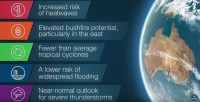
Communities across Australia are being reminded that now is the time to prepare, with the release of the Bureau's Severe Weather Season Outlook showing the country has an increased risk of heatwaves and bushfires in the coming months.
Parts of the country have already seen bushfires, and the Bureau's head of long-range forecasts, Dr Andrew Watkins, said the current state of Australia's climate drivers meant the likelihood of seeing more bushfire activity than normal was increased.
"The Bureau outlook shows we're likely to see more warmer and drier than average conditions for the coming months. This is due largely to a record strong positive Indian Ocean Dipole, that leads to drier air than usual over northwest Australia that supplies much of Australia's rainfall," Dr Watkins said.
"The increased odds of warmer than average days, coupled with a very dry landscape and a likely late start to the northern wet season, give a clear indication that we're likely to see more heatwaves than normal.
"It also adds to the potential bushfire risk, particularly when you consider how dry many parts of southern and eastern Australia are at the moment."
The Severe Weather Season Outlook also shows Australia has a lower risk of widespread flooding, and a near normal chance of severe thunderstorms, but Dr Watkins said the community needed to be prepared.
"Severe thunderstorms and significant rainfall events can happen at any time.
"Not being complacent and taking the time to know your weather and know your risk is one of the best ways to stay safe during the coming severe weather season."
The Bureau has also released its Tropical Cyclone Season Outlook, with the odds (65 percent) favouring fewer cyclones than normal.
Despite this, Dr Watkins was quick to point out that the risk from cyclones was always high.
"We've never had a tropical cyclone season without at least one cyclone crossing the coast. This means that despite a reduced risk this season, all communities in northern Australia must be ready," Dr Watkins said.
"Even if cyclones stay well out to sea, they can still pose a significant risk to property and lives through strong winds, intense rain and flooding, and storm surges."
Dr Watkins said on average, Australia sees roughly 11 cyclones each season, with four of those crossing the coast, but the current state of Australia's climate drivers, particularly the neutral state of the El Nino–Southern Oscillation and a positive Indian Ocean Dipole, meant the chances of seeing that amount this year are slightly reduced.
He added that cyclone formation was rarely spread evenly, with history showing quiet periods can be followed by bursts of intense activity.
"Remember, if your community is affected by severe weather, it's crucial you follow the advice of emergency services, and stay up to date with all the latest forecasts and warnings from the Bureau of Meteorology."
Know your weather. Know your risk. Stay up to date with the latest forecasts and warnings via the Bureau of Meteorology website (bom.gov.au), the BOM Weather app or on Twitter.
You can view the Bureau's severe weather outlook page here: http://www.bom.gov.au/weather-services/severe-weather-knowledge-centre/
You can view the Bureau's Tropical Cyclone Season Outlook here: http://www.bom.gov.au/cyclone/outlooks/index.shtml
You can view the Bureau's severe weather outlook video here: https://www.youtube.com/watch?v=rW6wEjxmZ_M&feature=youtu.be
