


Bureau of Meteorology raises La Nina status to active
29/09/2020
Download a video interview with Bureau Manager of Climate Operations Dr Andrew Watkins discussing La Niña and it's likely impacts: VIDEO
Regional summary video interviews with Dr Watkins are linked below.
Download an animated video explaining La Niña: VIDEO
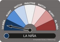
The Bureau of Meteorology has today declared that La Niña has developed in the Pacific Ocean, upgrading from a La Niña ALERT status to an active event.
This means that recent changes in ocean temperatures and weather patterns over the Pacific are now likely to remain until at least the end of the year.
La Niña is the cool phase of the El Niño Southern Oscillation. It is associated with cooler than average sea surface temperatures (SSTs) in the central and eastern tropical Pacific Ocean.
La Niña events often form in autumn or winter, then decay in late summer. The greatest impact normally occurs during the spring and early summer period.
La Niña events normally last for around a year, however they can be shorter, or much longer.
Recent observations and model forecasts show the central tropical Pacific Ocean is now 0.8°C cooler than normal, and that has resulted in changes to Trade Winds and pressure patterns. Climate models suggest these patterns will continue until at least the end of the year.
La Niña typically results in above-average spring rainfall for Australia, particularly across eastern, central and northern regions. It can also mean cooler days, more tropical cyclones, and an earlier onset of the first rains of the wet season across the north.
The last La Niña event occurred from 2010-2012 and resulted in one of Australia’s wettest two-year periods on record. Widespread flooding occurred in many parts of Australia associated with the record rainfalls.
Tropical cyclone activity in the 2010-2011 season was near normal. However, five of the tropical cyclones during 2010-11 were in the severe category, which is above average, including Tropical Cyclone Yasi, which caused widespread damage to far north Queensland.
The impacts of La Niña can vary significantly between events. It is likely this year will not see the same intensity as the 2010-11 La Niña event, but is still likely to be of moderate strength.
The Bureau previously shifted from La Niña WATCH to La Niña ALERT on 18 August 2020. The US National Oceanic and Atmospheric Administration declared an active La Niña status on September 10, 2020.
Regional summaries
South-east: VIDEO
- Tasmania, Victoria, South Australia and New South Wales typically have wetter than average conditions in La Niña years.
- Above-average rainfall is predicted for the whole south-east region.
South-west: VIDEO
- The eastern most parts of the south-west may see above-average rainfall.
North-west: VIDEO
- There is an increased potential for more tropical cyclones during La Niña.
- Above average rainfall is likely in the Kimberly and the Top End.
North-east: VIDEO
- The north-east, including northern NSW and all of Queensland should see above-average rainfall with a potential for increased flooding.
- The potential for more tropical cyclones crossing the coast increases in the far north-east during La Niña events.
