Severe Tropical Cyclone Seroja final update
12/04/2021

Severe Tropical Cyclone Seroja crossed the coast between Kalbarri and Geraldton Sunday evening. Damage near the track extended well inland
Key points
• Severe Tropical Cyclone Seroja crossed the coast as a category 3 cyclone Sunday evening
• Highest wind gust of 170km/hr recorded near Kalbarri
• Geraldton recorded 120km/hr wind gusts
• Highest rainfall 166.8mm recorded near Kalbarri
• Severe Tropical Cyclone Seroja brought strongest wind gusts to Geraldton since 1956, when 140km/hr was recorded from an unnamed cyclone
• Winds in Kalbarri and nearby areas from Severe Tropical Cyclone Seroja were likely to have been the strongest in more than 50 years
• No further severe weather from this system is expected, but the impact has been significant and will be ongoing
Seroja's path
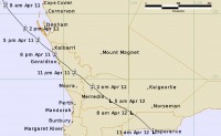
Severe Tropical Cyclone Seroja crossed the WA coast just south of Kalbarri, near the town of Port Gregory at 8pm Sunday evening as a Category 3 cyclone with winds gusts of 170 kilometres per hour observed in Kalbarri.
Winds of 120-140 kilometres per hour were observed in Geraldton, Northampton, Binnu, Chapman Valley and Mingenew.
Gusts over 100 kilometres per hour were observed through the Wheat Belt. Seroja has now moved offshore near Esperance.
Seroja was downgraded to below tropical cyclone intensity at 5 am Monday morning while moving across the eastern Wheat Belt.
The final severe weather warning for southeastern parts of the State have been now cancelled and no further severe weather from this system is expected.
Widespread damage has been reported including homes destroyed and power outages. Many people within the Bureau worked very hard to prepare Western Australians for the likely impacts. While we were able to provide accurate and timely forecasts seeing the devastation from Severe Tropical Cyclone Seroja is distressing. We will continue to serve the communities affected and work with all relevant agencies to help with recovery efforts as we can.
Weather records
The last time Geraldton experienced such intense winds from a tropical cyclone was in 1956 when a wind gust of 140 km/h was recorded. Winds in Kalbarri and nearby areas from Severe Tropical Cyclone Seroja were likely to have been the strongest in more than 50 years.
The path Seroja took across WA crossing the coast as a Severe Tropical Cyclone and continuing inland eventually as a tropical low is below.
Significant observations across the State:
Maximum wind gusts
• Meanarra Tower (near Kalbarri) 170km/h @19:03 AWST Sunday
• Binnu West (DPIRD) 139km/h @19:47 AWST Sunday
• Geraldton Airport 120km/h @20:51 AWST Sunday
• Dalwallinu 107 km/hr @00:50 AWST Monday
Rainfall since 9am Sunday
• DBCA Meanarra Tower (near Kalbarri) 166.8mm
• Binnu West (DPIRD) 75.6mm
• Carnarvon (DPIRD) 62.8mm
• Eradu (DPIRD) 55.6
Forecast for the rest of this week
Colder than average temperatures are forecast from tomorrow for the south west of the State.
Showers and thunderstorms possible in parts of the Kimberley, Pilbara, Gascoyne, and Goldfields.
Perth showers are clearing today.
.jpg)
ENDS


