


WA's coldest front so far this year expected this weekend
20/05/2021
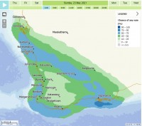
Two cold fronts are expected to arrive this weekend in Western Australia's South West, bringing showers, possible storms and even the potential for snow.
The first front on Saturday will bring widespread rain to the South West of the state, while the second cold front, arriving on Sunday, will be the coldest front experienced in WA this year.
Snow is possible on Sunday night on Bluff Knoll in the Stirling Ranges.
Temperatures will drop from 6-9°C through inland parts of the south west between Friday and Sunday. Perth will only get to a high of 19°C on Sunday, 17°C on Monday, and cold conditions will continue throughout early next week. Wind chill will make it feel even colder.
Monday is forecast to be the coldest day. Katanning is expected to record the coldest temperature of 11°C, with several other places in the Great Southern expected to only reach 12°C.
The coldest morning is forecast to be Tuesday. Areas in the Wheat Belt and Great Southern may only reach 2-3°C overnight.
A vigorous southerly air stream from the Southern Ocean is driving this early taste of winter, particularly with the second, stronger cold front.
The last time we had snow was in 21 September 2020 at Bluff Knoll. Prior to that a dusting of snow occurred on 19 April in 2019 and a heavier fall on 9 August 2018, also at Bluff Knoll.
Typically when snow falls in WA it's between July and September, but has arrived as early as April.
Read the BOM Blog: 'All your snow questions answered' here.
Even though severe weather is unlikely, people should take care on the roads and be prepared for very cold and windy conditions if they are in the Stirling Ranges.
Dangerous surf conditions are likely to develop along the coastline between Jurien Bay and Esperance on Monday.
ENDS
