


WA coastal communities urged to prepare for severe weather
08/06/2021
Western Australian communities are expected to be impacted from two weather systems, with heavy rain starting early Wednesday in parts of the Pilbara and Gascoyne and severe weather conditions in the south west intensifying Wednesday morning.
In the north
Rain from a trough in the west Pilbara and adjacent Gascoyne could produce heavy falls, that may cause localised and flash flooding.
Forecasts for rain include 30-60mm and isolated falls up to 100mm Wednesday in coastal areas between Denham and Mardie, and adjacent inland areas to Mount Augustus. On Thursday a further 20-40mm with isolated falls up to 65mm is expected between Exmouth and Karratha.
Further south
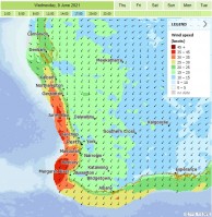
An approaching low-pressure system will cause winds to turn northerly, intensifying in strength particularly between Geraldton and Albany, including Perth. While winds of this intensity are not unusual in winter, typically they’re from the opposite direction, south.
There is a risk of localised damaging winds in coastal locations between Mandurah to Walpole, and adjacent inland areas. Gale force winds are likely over coastal waters.
Across the South West Land Division 10-25mm of rainfall is forecast near the west coast and 5-15mm elsewhere.
Waves and Storm Surge
The low, positioned offshore, is also expected to generate dangerous surf and swell as well as abnormally high tides that could cause coastal inundation particularly around the Geographe Bay area. Marine wind warnings are already current, and viewable here.
The highest tide is expected Thursday morning (including half a metre above normal expected tide between Bunbury and Geographe Bay). However, conditions are expected to ease by Thursday afternoon as the low-pressure system contracts well south of the state.
Perth
In Perth rainy, windy conditions are forecast from Wednesday to Thursday before easing on the weekend.
Stay up to date with forecasts here and warnings here.
ENDS
