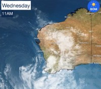
Stormy weather is now easing in Western Australia, but showers to continue
10/06/2021

Localised flooding is occurring in Exmouth following heavy overnight rain, while tides rose well above their typical highest points across a number of coastal locations including Perth where Riverside Drive was inundated.
Damaging winds are no longer expected, but strong wind warnings remain. In the past 24 hours the strongest wind gusts were recorded at Cape Naturaliste (94km/hr), Rottnest Island (91km/hr) and North Island in the Abrolhos (81km/hr). The highest wind gust in Perth was recorded in Bickley at 72km/hr.
A severe weather warning for a narrow strip hugging the coastline from Bunbury to Walpole is current for abnormally high tides and damaging surf.
After a very cool day yesterday, it was a much warmer Thursday morning in Perth due to the winds turning to the north west, bringing warmer, moisture-laden air off the ocean.
Conditions are now easing, as the low-pressure system tracks south of the state. For the remainder of Thursday and Friday showers and thunderstorms will continue at times across the South West Land Division, Goldfields, Gascoyne, parts of the Pilbara, interior and Eucla.
This weekend there will be intermittent showers across much of the South West Land Division, including Perth. Showers are also forecast in the Goldfields, Gascoyne, central Pilbara, south interior and Eucla on Saturday, and continuing in the Eucla, south coast on Sunday.
View warnings here and forecasts here.
ENDS


