


Off and on stormy southwest WA weather to pick up again from late Wednesday
13/07/2021
85-100 kilometre per hour wind gusts have been recorded in the past 24 hours across southwest WA.
Damaging gusts are no longer likely today, but higher than normal tides, elevated sea swells and squally conditions will persist for the remainder of Tuesday and early Wednesday morning.
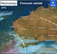
There will be a lull during much of Wednesday before a second burst of stormy weather picks up from Wednesday evening into Thursday.
The next bout of stormy weather arriving Wednesday evening will bring the risk of possible damaging winds again for areas south of Perth and along the southern coast.
Perth has already exceeded its monthly average of rain for July (145mm as at 2pm WA time. July average is 142.3mm). It is Perth's wettest start to July since 2000 (based on Perth metro site observations since 1993).
For much of this week dangerous surf will continue as far north as Jurien Bay, as will higher than normal tides and possible inundation of low-lying coastal areas, as happened with Riverside Drive in Perth on Tuesday.
Small hail is forecast near the coast south west of Mandurah from Wednesday evening into Thursday.
Friday and Saturday will bring a reprieve from the bad weather before a very weak cold front brushes up against the south coast again on Sunday bringing an increase in showers across the southwest including in Perth.
Monday wind gusts:
- 100 kph at 9:30pm at Cape Leeuwin
- 100 kph at 7:05pm at Mandurah
- 93 kph at 7.20pm at Rottnest Island
- 89 kph at 11:59pm at Cape Naturaliste
- 87 kph at 7:28pm at Dwellingup
- 85 kph at 8:35pm at Gooseberry Hill
Tuesday wind gusts:
- 98 kph at 3:21am at Cape Leeuwin
- 85 kph at 12:20am at Cape Naturaliste
