Wind, Rain & Possible Snow NSW ACT Update
16/07/2021

Please find below the link to an on-camera interview with the Bureau of Meteorology's Melody Sturm, with an update on the weather system impacting NSW and the ACT: https://we.tl/t-mgyg9zUYHf
- Much of NSW and the ACT will experience gusty and potentially damaging wind conditions, building from today (Friday) and through Saturday in many areas
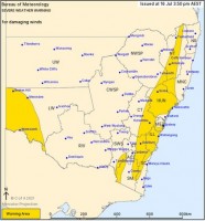
- Severe Weather Warnings are currently in place, effectively stretching from the Victorian to Queensland borders in eastern regions, with an additional area in the far west
- These winds have the potential to bring down trees and powerlines, and emergency services are urging people to clean-up loose items around their properties, take care if involved in outdoor activities, and reconsider marine activities such as boating or rock fishing
- The Cold Front causing the windy conditions will also bring additional snow falls to alpine areas, with blizzard conditions possible
- Snow levels are expected to drop significantly on Saturday, with light falls possible in parts of the Monaro Country, Southern Tablelands, ACT and Central Tablelands. Although it's unlikely any snow that does fall will be deep or long lasting
- Snow and ice may lead to dangerous conditions on the roads, and drivers are being urged to take care
- Showers are forecast for many districts, with more persistent rain periods likely about parts of the tablelands and western slopes. Thunderstorms and small hail are also possible
- While rain totals are not expected to be high in most areas, many catchments are near saturation, so riverine flooding is a risk, and a number of Flood Watches and Warnings are currently in place
**Please note there are two video files available for download at the above link. The larger of the two is the primary interview, the smaller file relates specifically to the far west of NSW.


