Southwest WA's wet July continues as more rain forecast
19/07/2021

More rain is forecast for Perth and southwest WA, with today marking 16 consecutive days of rain in Perth.
For much of where WA's population resides this month has been notably wet with July rainfall averages already exceeded in many places within the southwest as well as the broad South West Land Division, that takes in from Kalbarri to Esperance, as a whole.
The last time we had 16 consecutive rainy days in Perth was in 2009. There have been 20 spells of 20 or more rainy days in a row in Perth, but only three in recent decades (1987, 1996, 2009).
With 179.6mm of rain recorded so far in Perth this month (July average is 142.3mm) and more rain expected Perth is on track to record more than 200mm of rain this month, which would only be the fourth time since 1993.
The most rain ever recorded at the Perth metro site in any month was 278.6mm in July 1995.
Forecast
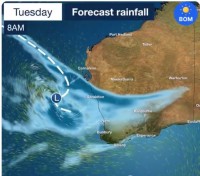
Rain that fell this morning over the Central West will extend across Perth and the South West Land Division overnight and tomorrow as a rain band moves eastwards.
Things will also get blustery as a low pressure system brings strong winds on Wednesday to much of southern WA, particularly coastal areas between Kalbarri and Esperance.
The heaviest of Tuesday's rain is forecast to fall in the Central West, then move to south coastal parts on Wednesday.
Tuesday's rain includes falls of 15-30mm across the Central West and northern Central Wheat Belt with isolated falls up to 50mm possible.
For Perth 10-25mm is possible across Tuesday and Wednesday.
Conditions will ease Thursday before another cold front moves through southern parts on Friday.


