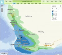
Heavy rain and dangerous winds expected across southwest WA on Monday and Tuesday
27/07/2021

Dangerous winds have eased from the west coast Tuesday morning and will ease across southern parts of the State later this afternoon.
Apart from continuing showers much of the southwest will now experience a slight reprieve from stormy conditions until gusty winds and rain increase once more during Thursday.
245.8mm of rain has now fallen at Perth this month, 73% above the monthly average. It is the wettest July in Perth for 26 years, when 278.6mm was recorded in 1995. The most rain ever recorded in July in Perth occurred in 1958 when 425mm fell.
It is also the wettest July since the mid 2000s for much of the Great Southern and Central Wheat Belt Districts. For the entire South West District current July rain compares to 2018 falls, but this is still wetter than most years this century.
The latest rainfall has triggered river rises across the Perth, Southwest and Avon River regions. Rivers are being closely monitored considering further incoming rainfall. Many rivers are flood heights not seen in decades.
Forecast
Widespread falls of 10-25mm are expected across the southwest during Thursday and Friday. The heaviest falls are likely in western parts between Perth and Walpole, with isolated falls of 40-50mm possible about the Darling Scarp throughout the event.
A flood watch is current for possible flooding in the Swan, Murray and Harvey River catchments.
A flood warning has been issued for the Avon River catchment.
Damaging surf conditions that could cause significant beach erosion between Shark Bay and Israelite Bay are expected to continue for the rest of the week.
The next cold front may also cause a light smattering of snow to fall at the Stirling Ranges early Saturday morning, most likely before sunrise.
Notable recent observations
Severe wind gusts recorded early morning Tuesday 27 July:
- Cape Leeuwin 135 km/h at 2:46am
- Busselton Jetty 124 km/h at 2:51am
- Cape Naturaliste 124 km/h at 4:28am
- Pearce 113 km/h at 6:06pm (on Monday 26 July)
- Busselton Airport 100 km/h at 2:54am
- Garden Island 100 km/h at 5:28am
- Gooseberry Hill 100 km/h at 5:36am
- Rottnest Island 98 km/h at 5:04am
- Mandurah 98 km/h at 5:35am
- Ocean Reef 95 km/h at 3:45am
- Bunbury 95 km/h at 4:58am
- Jandakot 91 km/h at 5:08am
- Bickley 91 km/h at 5:26am
- Walpole North 91 km/h at 5:28am
24 hour rain totals to 9am Tuesday 27 July:
- Jarrahdale: 85mm (including 27.6mm in 1 hour)
- Mount William: 81mm
- Jarrahdale: 75.4mm
- Dwellingup: 69.2mm
- Bickley 59.8mm
- Jandakot 47.4mm
- South Perth 41.2mm
- Floreat 40.8mm (including 27.4mm in 1 hour)
- Swanbourne 37.2mm (including 24.4mm in 1 hour)
- Garden Island 35.4mm
Stay up to date with warnings and flood watches here.


